Advertisement

A Very Good Shot at 100F on Wednesday

Enjoy a cool breeze this morning because a well-advertised "heat spike" is on the way, a sudden surge in temperature. After reasonable 80s today I see upper 90s Tuesday and 100F Wednesday. Expect a heat index both afternoons from 105 to 110F. Stupid Hot. Check the blog for more details. -Todd Nelson

August 21, 2023 at 2:30AM
Advertisement

Excessive Heat This Week

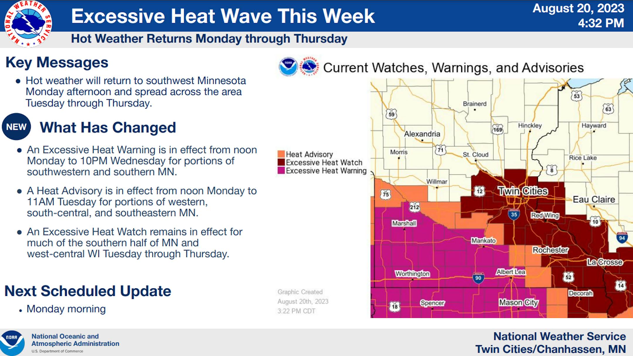
EXCESSIVE HEAT WATCH NOW IN EFFECT FROM TUESDAY MORNING THROUGH THURSDAY EVENING

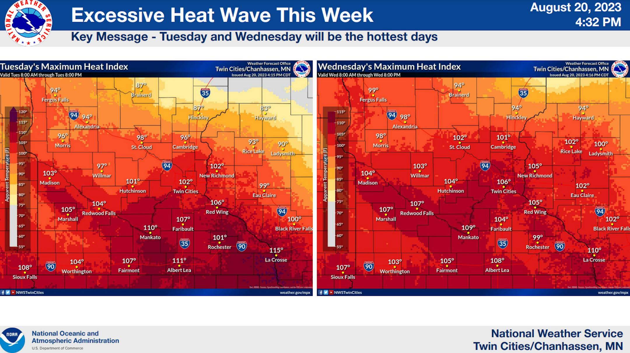
WHAT...Dangerously hot conditions with heat index values up to 107 possible.

WHERE...Portions of central, east central, south central and southeast Minnesota and west central Wisconsin.

WHEN...From Tuesday morning through Thursday evening.

IMPACTS...Extreme heat and humidity will significantly increase the potential for heat related illnesses, particularly for those working or participating in outdoor activities.

ADDITIONAL DETAILS...The heat should start waning by Thursday, but the cumulative effect from multiple days of excessive heat may lower one`s tolerance to handle it. The extreme heat may also lead to buckling roads.

PRECAUTIONARY/PREPAREDNESS ACTIONS... Monitor the latest forecasts and warnings for updates on this situation. Be prepared to drink plenty of fluids, stay in an air-conditioned room, stay out of the sun, and check up on relatives and neighbors. Young children and pets should never be left unattended in vehicles under any circumstances. This is especially true during warm or hot weather when car interiors can reach lethal temperatures in a matter of minutes.

Excessive Heat This Week (NWS Twin Cities/The Minnesota Star Tribune)

Heat Index Values on Tuesday & Wednesday

Heat Index Values on Tuesday & Wednesday (NWS Twin Cities/The Minnesota Star Tribune)

August 21st, 1883 Rochester Tornado & The Mayo Clinic

"During the late afternoon and evening of August 21, 1883, three significant tornadoes (two F3s and one F5) occurred in southeast Minnesota. These tornadoes affected parts of Dodge, Olmsted, and Winona counties, and they accounted for 40 fatalities and over 200 injuries. Prior to these tornadoes, there were only three hospitals in the state of Minnesota outside of the Twin Cities. None of these hospitals were located near Rochester. After the F5 tornado struck Rochester, a dance hall (Rommel Hall) was transformed into a temporary emergency room. Doctors William Mayo and his two sons (William and Charles) took charge of caring for patients. Mother Mary Alfred Moes of the Sisters of St. Francis helped care for patients as well. After this disaster the Mayo family and the Sisters of St. Francis realized the need of a hospital in Rochester. They banded together to form St. Mary's Hospital, which ultimately led to the creation of the Mayo Clinic."

Advertisement
1883 Rochester MN Tornado Aftermath (NWS La Crosse: Photo taken by Elmer & Tenney/The Minnesota Star Tribune)

Hilary Soaked Southern California

Tropical Storm Hilary made landfall in the Baha California Peninsula around midday Sunday and moved into southern California later in the day. Areas of heavy rain and gusty winds were the main concerns as Hilary lifted north through the region. At one point, Hilary was a major category 4 with sustained winds of 145mph early Friday morning!

Tropical Storm Hilary From Midday Sunday (NOAA Satellite/The Minnesota Star Tribune)

Tracking Hilary

Hilary will continue to weaken as it drifts north into the Western US. Areas of heavy rainfall and gusty winds will still be possible with flooding and mudslides possible as the remnants pass through the region.

Tracking Hilary (NOAA NHC/The Minnesota Star Tribune)

Tracking Hilary

Here's the simulated radar from early AM Monday to AM Tuesday as the remnants of Hilary drift north through the region. Gusty winds and heavy rainfall will still be the primary threats, with isolated flash flooding events possible.

Tracking Hilary (COD Weather/The Minnesota Star Tribune)

Extreme Rainfall

Areas of heavy rainfall will begin to wind down through the region early this week with the heaviest rains occurring across southern California and into Nevada.

Heavy Rains From Hilary (NOAA WPC/The Minnesota Star Tribune)

Could Heavy Rainfall From A Storm Like Hilary Trigger An Earthquake?

"The U.S. Geological Survey has reported a Magnitude 5.1 earthquake 7 km southeast of Ojai, California on Sunday. This report comes as Tropical Storm Hilary is moving through the region and producing extreme rainfall. Heavy rainfall will continue to be a problem for southern California and the Southwest through Sunday evening. Herein, I pose the question - "Is southern California earthquake linked to rainfall from the tropical storm? To be clear, I have absolutely no evidence to say "yes" to that question and to do so would be completely speculative. However, I thought that it would be informative to make you aware of scientific studies in the literature on the topic. A 2006 study published in Geophysical Research Letters was entitled, "Evidence for rainfall-triggered earthquake activity." They found that seismic activity was highly correlated with pore pressure changes associated with diffusing rainwater. The physics get a bit complicated, but there is discussion of rainwater channeling into open fractures and precipitation into a limited number of open fractures. These processes lead to hydraulic changes that could be linked to earthquakes."

Advertisement
Earthquakes from August 20th (USGS/The Minnesota Star Tribune)

Franklin Develops in the Atlantic

Tropical Storm Franklin developing in the Caribbean on Sunday, which is now the 6th named storm of the 2023 season. Tropical Alerts have been issued for parts of Haiti and the Dominican in advance of Franklin as it lifts north.

Tropical Storm Franklin from PM Sunday (NOAA Satellite/The Minnesota Star Tribune)

Tracking Franklin

Here's the forecast for Franklin, which shows the storm drifting over Haiti and the Dominican with gusty winds and heavy rainfall midweek before lifting northeast into the Central Atlantic later in the week as a hurricane.

Forecast For Franklin (NOAA NHC/The Minnesota Star Tribune)

Emily Develops in the Atlantic

Meanwhile, Tropical Storm Emily developed in the Central Atlantic on Sunday, which becomes the 5th named storm the 2023 season. The good news is that this storm should remain over open waters and will not be an issue for anyone closer to home.

Tropical Storm Emily From Midday Sunday (NOAA Satellite/The Minnesota Star Tribune)

Tracking Emily

Here's the forecast track for Emily. According to NOAA's NHC, this storm will slowly drift north through the week ahead.

Tracking Emily in the Atlantic (NOAA NHC/The Minnesota Star Tribune)

Active Weather in the Atlantic

Well all of the sudden, the Atlantic woke up. According to NOAA's NHC, there are several disturbances in the basin that we'll have to keep an eye on over the next several days. A few are closer to home and could be somewhat problematic, so keep an eye on that.

Advertisement
7 Day Tropical Outlook for the Atlantic (NOAA NHC/The Minnesota Star Tribune)

Atlantic Basin Climatology

Our recent uptick in the Atlantic tropical activity coincides with climatology, which suggests that things ramp up pretty quickly during the 2nd half of August and into September. This is when the sea surface temperatures are typically the warmest in the Atlantic Basin. Note that the actual peak of the season is on September 10th, which is less than 3 weeks away. With that being said, the next several weeks could be pretty active in the Tropics.

Atlantic Hurricane & Tropical Storm Climatology (NOAA NHC/The Minnesota Star Tribune)

Another Hot Week Shaping Up

According to NOAA's National Blend of Models, it is going to be another very hot week with temperatures warming into the 90s a few days and possibly up to 100F midweek. Good grief! Note that our hottest temperature at the MSP Airport was 96F on July 27th, so we could certainly see our hottest day of the year this upcoming week.

NBM Extended Temperature Outlook For MSP (WeatherBell/The Minnesota Star Tribune)

Rare 100F Degree Days at MSP in August

Interestingly, it's pretty rare to see a 100F day in August. Since records started back in 1872, there have only been (7) 100F degree days, with the most recent happening back in 1988, which is 35 years ago.

Rare 100F Days at MSP in August (NOAA NWS/The Minnesota Star Tribune)

Hottest Days of 2023 So Far

The hottest day of 2023 (so far) was Thursday, July 27th with a high of 96F and heat index values peaking around 105F to 110F. Uffda! Through Saturday, August 19th, there had been (24) 90F days this year. It looks like we'll add a few more to that list this week.

Hottest Day of 2023 at MSP So Far This Year (NOAA NWS/The Minnesota Star Tribune)

11th Hottest Meteorological Summer on Record

It has also been a hot summer with readings running well above average since June 1st and good enough for the 11th hottest Meteorological Summer on record so far (through August 19th). Note that 2021 was the 2rd hottest and 2022 was the 17th hottest From June 1st to August 19th. With several hot days in the forecast, we're likely to see this summer jump up a few spots this week. Stay tuned...

11th Warmest Summer So Far at MSP (NOAA NWS/The Minnesota Star Tribune)

Average Number of 90F Days At MSP

Looking at the last 30 years, the average number of 90F days at the MSP Airport is (14). July is the hottest month with an average of (6) 90F days. This year we've had (23) 90F days, last year we had (18) days in the 90s and in 2021 there were (27) days in the 90s. The most number of 90F days in any single year was (44) set in 1988.

Advertisement
Average Number of 90F Days At MSP (NOAA NWS/The Minnesota Star Tribune)

16th Driest Meteorological Summer on Record

It has been very dry across much of the region so far this summer with only 5.79" of rain falling at the MSP Airport since June 1st. Interestingly, we're still -5.63" below average this summer, even with the +1.00" that fell in the metro on Sunday, August 13th. For reference, the driest on record was only 1.65" set in 1894. Interestingly, the summers of 2021 and 2022 were even drier.

16th Driest Summer on Record at MSP (NOAA NWS/The Minnesota Star Tribune)

90 Day Precipitation Anomaly

On average, the wettest time of the year is in the summer, with the months of June, July and August seeing nearly 13" of rain at the MSP Airport. If we take a look at the 90 day precipitation anomaly, which dates back to about mid May, some locations are nearly -3.00" to nearly -7.00" below average (in red/pink). Note that some locations across southeastern Minnesota are nearly -8.00" to -10.00" below average.

90 Day Precipitation Anomaly (WeatherBell/The Minnesota Star Tribune)

Drought Update

After a decent, steady, soaking rain across parts of the state last weekend, there was a slight improvement in drought across parts of the state. Most categories dropped slightly, but there are still a few areas across southeastern Minnesota, that are in an Extreme Drought (in red). The last time that parts of Minnesota were in an Extreme Drought was back in mid December, nearly 8 months ago.

Minnesota Drought Update (US Drought Monitor/The Minnesota Star Tribune)

Extended Precipitation Outlook

Thanks to some hot weather over the next several days, it appears that we'll stay mostly dry across much of the state through the week ahead. There could be a few areas of showers and storms across the northern part of the state with the heaviest of 0.50" or more along the international border.

Extended Precipitation Outlook (WeatherBell & NOAA's WPC/The Minnesota Star Tribune)

Twin Cities Weather Outlook For Sunday

The weather outlook for the Twin Cities on Sunday, August 21st will still be quite warm, but not as hot as it was on Saturday. Highs will be nearly 10F cooler than there were on Saturday. However, dewpoints will be increasing through the day and become quite sticky later in the afternoon as readings approach the tropical mark of 70F once again. Skies will be a bit hazy through much of the day with some clearing late.

Twin Cities Weather Outlook For Monday (Praedictix/The Minnesota Star Tribune)
Hourly Dewpoint Forecast For Minneapolis on Monday (Praedictix/The Minnesota Star Tribune)

Meteograms For Minneapolis

The weather outlook for Minneapolis through the day Monday will get pretty warm once again with highs warming into the mid 80s and dewpoints climbing to near 70F. Skies will be somewhat cloudy with more clearing late in the day. East to southeasterly winds will be breezy with gusts approaching 20mph through the day.

Hourly Temps & Sky Conditions For Minneapolis on Monday (Praedictix/The Minnesota Star Tribune)
Hourly Wind Gusts & Direction For Minneapolis on Monday (Praedictix/The Minnesota Star Tribune)

Weather Outlook For Monday

Temps on Monday will be pretty interesting across the state depending on where you are. If you're close to the Canadian border, readings will only warm into the 60s, which will be nearly -10F below average with areas of rain and thunder. Farther south, it'll be hot and sticky as temps warm into the 90s, which will be nearly +10F to +20F above average.

Weather Outlook For Monday (Praedictix/The Minnesota Star Tribune)
Highs From Average on Monday (Praedictix/The Minnesota Star Tribune)

Extended Temperature Outlook For Minneapolis

Temperatures in Minneapolis through the week ahead will get hot once again with readings nearly +15F to +20F above average Tuesday, Wednesday and Thursday. There is an outside chance that we hit 100F on Wednesday, which would only be the 8th time we've seen 100s at MSP during the month of August.

5 Day Temperature Outlook For Minneapolis (Praedictix/The Minnesota Star Tribune)

Record Highs Possible This Week

With highs warming into the mid/upper 90s (and possibly 100F) this week, we could be near record warmth! We'll be within striking distance on Tuesday, Wednesday and Thursday, with the most likely day of exceeding the record being Wednesday.

Possible Records For MSP This Week (Praedictix/The Minnesota Star Tribune)

Hot & Sticky This Week

The 5 day dewpoint and heat index forecast for Minneapolis looks quite a bit hotter and stickier as we approach mid week once again. Dewpoints will likely climb and hover in the mid/upper 60s and lower 70s late Monday through Thursday. With temperatures warming into the mid/upper 90s mid week, we'll likely see heat index values approaching the 100F mark once again.

Daily Max Dewpoints For Minneapolis (Praedictix/The Minnesota Star Tribune)
Daily Peak Heat Index For Minneapolis (Praedictix/The Minnesota Star Tribune)

Extended Weather Outlook For Minneapolis

After a much nicer and more comfortable Sunday, it'll get hot again with highs back in the mid/upper 90s and feels like temps back to around 100F or better. The end of the week will get a little better with readings back in the mid 80s, but it'll be even better by the weekend with highs warming into the 70s.

7 Day Weather Outlook For Minneapolis (Praedictix/The Minnesota Star Tribune)

Weather Outlook

Thanks to a large dome of high pressure in the Central US, there won't be much rain over the next 5 to 7 days there. It'll be hot with widespread records, but most of the rain and thunder will be found on the outer periphery of this "ring of fire".

National Weather Outlook Through Next Weekend (Tropical Tidbits/The Minnesota Star Tribune)

8 to 14 Day Temperature Outlook

According to NOAA's Climate Prediction Center, the 8 to 14-day temperature outlook shows Warmer than average temperatures across much of the nation with the exception of the Northeast, where temps will remain cooler than average into the end of August and into early September.

8 to 14 Day Temperature Outlook (NOAA CPC/The Minnesota Star Tribune)

8 to 14 Day Precipitation Outlook

According to NOAA's Climate Prediction Center, the Western US looks a little more unsettled across the Western US. Meanwhile, drier weather will settle in across the Central and Southern US.

8 to 14 Day Precipitation Outlook (NOAA CPC/The Minnesota Star Tribune)

A Very Good Shot at 100F on Wednesday
By Paul Douglas

Stuff I never thought I'd see: tornado chasers searching for twisters in California as "Hilary" sloshed overhead. A heat index of 134F in Lawrence, Kansas yesterday - only 475 miles south/southwest of MSP. All residents of a single Canadian province (Northwest Territories) evacuated due to wildfires. Smoke shelters opening up in Spokane, Washington, so locals could breathe clean air. Symptoms of a warming climate are harder to miss in the summer, and never more so than 2023.

Enjoy a cool breeze this morning because a well-advertised "heat spike" is on the way, a sudden surge in temperature. After reasonable 80s today I see upper 90s Tuesday and 100F Wednesday. Expect a heat index both afternoons from 105 to 110F. Stupid Hot.

According to the Twin Cities National Weather Service, MSP hasn't recorded a 100-degree high in August since 1988 (35 years). It's happened 7 times since 1873.

No significant rain, just a late week cooling trend. Highs near 80F with low humidity at the fair this weekend? Sign me up!

Extended Forecast

MONDAY: Partly sunny and warm. Winds: SE 10-20. High: 86.

MONDAY NIGHT: Partly cloudy and mild. Winds: ESE 10-15. Low: 74.

TUESDAY: Heat dome arrives. Feels like 105+. Winds: SE 10-20. High 97.

WEDNESDAY: Hottest August day in 35 years? Winds: SW 8-13. Wake-up: 78. High: 100.

THURSDAY: Plenty of sun, slight relief. Winds: N 8-13. Wake-up: 72. High 92.

FRIDAY: Sunny and more tolerable. Winds: N 5-10. Wake-up: 70. High 87.

SATURDAY: Partly sunny, tolerable humidity. Winds: E 8-13. Wake-up: 64. High: 81.

SUNDAY: Blue sky, very nice. Winds: SE 5-10. Wake-up: 62. High: 80.

This Day in Weather History

August 21st

1918: Minnesota's third deadliest tornado strikes Tyler and destroys the downtown area, leaving 36 dead.

1886: High winds hit Northfield with winds blowing at 60 mph for 20 minutes. Peak gusts up to 75-80 mph are recorded.

1883: The 4th deadliest tornado in Minnesota history hits Rochester. The tornado kills 31 residents and injures 100 more. Appalled by the lack of medical care received by the tornado's victims, Mother Alfred Moes, founder of the Sisters of St. Francis, proposes to build and staff a hospital if Dr. W.W. Mayo will provide medical care. St. Marys Hospital opens in 1889 with 27 beds and eventually grows into the Mayo Clinic.

Average High/Low for Minneapolis

August 21st

Average High: 80F (Record: 98F set in 1947)

Average Low: 62F (Record: 44F set in 2004)

Record Rainfall: 3.64" set in 1924

Record Snowfall: NONE

Twin Cities Almanac For August 21st (Praedictix/The Minnesota Star Tribune)

Sunrise/Sunset Times for Minneapolis

August 21st

Sunrise: 6:2am

Sunset: 8:10pm

Hours of Daylight: ~13 hours & 47 minutes

Daylight LOST since yesterday: 2 Minutes & 52 Seconds

Daylight LOST since Summer Solstice (June 21st): ~ 1 Hour & 50 Minutes

Moon Phase for August 21st at Midnight

2.1 days before Frist Quarter moon

Moon Phase For August 21st at Midnight (Weather/The Minnesota Star Tribune)

National High Temps on Monday

Temperatures on Monday will be extremely hot across the Central US with highs running nearly +5F to +15F above average. Widespread records will be found across the Central and Southern Plains and also down across parts of the Lower Mississippi Valley. Meanwhile lingering heavy rains and gusty winds will impact parts of the Western US, where the remnants of Hilary will drift through.

National Weather Outlook For Monday (Praedictix/The Minnesota Star Tribune)
National Highs From Average on Monday (Praedictix/The Minnesota Star Tribune)

National Weather Monday

The weather outlook on Monday will feature lingering showers and storms the Western US, where remnants of Hurricane Hilary will drift through. Meanwhile, the Central US will remain hot and dry with record heat.

National Weather Map For Monday (Praedictix/The Minnesota Star Tribune)

National Weather Outlook

The weather outlook through Tuesday shows widespread showers and storms across the Western US, where the remnants of Hurricane Hilary will be found. Not much will happen across the Central US, where temperatures will be too hot for any substantial rain anytime soon.

National Weather Outlook For Tuesday (NOAA WPC/The Minnesota Star Tribune)

Extended Precipitation Outlook

The extended precipitation outlook looks pretty interesting over the next 7 days. This is a pretty typical setup for what is known as a "Ring of Fire", where areas of heavy rainfall develop on the outer periphery of the dome of extreme heat in the Central US.

Extended Precipitation Outlook (NOAA WPC/The Minnesota Star Tribune)

Climate Stories

(NOAA/The Minnesota Star Tribune)

"Extreme Heat Can Kill. Here's How the National Parks Protect Visitors"

"As high temperatures roll across the globe, hikers may be getting a glimpse of their future. Historic data indicate that heat waves have been increasing in frequency, intensity, and duration—and without aggressive climate change measures, these trends are predicted to continue in future decades. This summer's heat waves are threatening hiker safety: Multiple hikers have died in national parks this year, with the National Park Service stating that extreme heat likely played a role. At least five people are suspected to have died in three national parks due to the heat this summer: Big Bend National Park, Grand Canyon National Park, and Death Valley National Park. Jeff Stebbins, a Public Affairs Specialist at Grand Canyon National Park, said that data indicate a 71 percent increase in the volume of distress calls when temperatures hit 95°F. "So far this year, our SAR team has responded to 181 calls," he said."

"Record heat boosting wildfire risk in Pacific Northwest"

"A record heat wave in the Pacific Northwest has prompted fire managers to bump the national preparedness level up a notch, from three to four on a five point scale. More than two dozen large fires are now burning in the region, many sparked by dry thunderstorms. At the National Interagency Fire Center in Boise, federal fire managers monitor giant screens in a NASA like control room, as they deploy air tankers, hot shot crews and other resources around the West right now. Meagan Conry, the federal Bureau of Land Management's assistant deputy director for fire and aviation, tracks fires on live cameras in the Northwest. She says the area has become vulnerable to increased fire activity because of, "above average temperatures, dry conditions, and some expectations for gusty winds over the next few days."

"Original Twister director says film could not be remade today, even if a sequel is currently in the works"

"1996's Twister was a big, big blockbuster about big storms that cause big things to fall out of the sky and wreak havoc on the ground below. It could also never be made today according to its director Jan de Bont—but not for any of the reasons people usually think when they use that phrase. "When things fell from the sky, there were real things falling from a helicopter," the director told Inverse in a recent interview. "If you film a car escaping a tornado in a hail storm, it was real ice that came at us. It's a movie that cannot be remade… That would never, ever happen again." Hmm... okay. We have some things to say. First of all, one of the things that fell out of the sky was a cow. Literally a whole ass, still-mooing bovine. It's pretty hard to believe that poor Bessie was just launched out of a helicopter for the bit, even if she was just a model. (Please do yourself a favor and click play on this clip, even if you've seen this movie recently. Helen Hunt's deadpan "cow" and Jami Gertz's "I gotta go, we got cows" are both line deliveries for the ages.)"

Thanks for checking in and don't forget to follow me on Twitter @TNelsonWX

@TNelsonWX (The Minnesota Star Tribune)
about the writer

about the writer

Todd Nelson

See Moreicon
Advertisement