A Quiet, Pleasant Week Shaping Up

Cue an August reprieve with 80s returning; 90Fis not out of the question Thursday. A cooler front may trigger a brief smear of rain late Friday with daytime highs in the low 70s next weekend and seasonably comfortable weather next week. Check the blog for more details. -Todd Nelson

September 6, 2022 at 4:34AM
(@TNelsonWX/The Minnesota Star Tribune)

Dry Week Ahead - Storm Chance This Weekend

Here's the weather outlook from AM Tuesday to AM Monday. Weather conditions will remain quiet and mostly dry through the first full week of September. Later this week and into the weekend, there is a slight chance of showers and storms as a storm system slides through.

Weather Outlook From AM Tuesday to AM Monday (Tropical Tidbits/The Minnesota Star Tribune)

Extended Precipitation Outlook

Weather conditions look exceptionally dry over the next several days, but later this week and weekend ahead could feature showers and storms. According to NOAA's WPC, there doesn't appear to be much rainfall potential.

Extended Precipitation Outlook (WeatherBell & NOAA's WPC/The Minnesota Star Tribune)

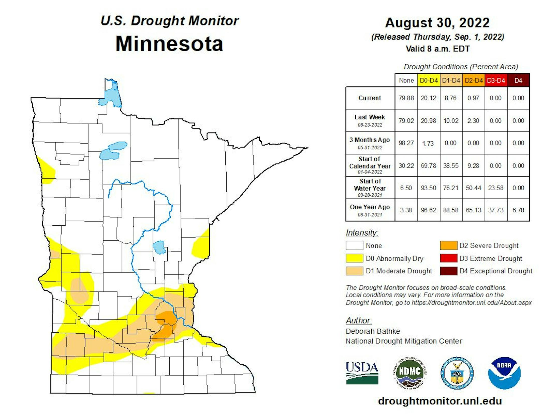
Minnesota Drought Update

Here's the latest drought update across Minnesota. Thanks to a little more rain last week, severe drought has dwindled to less that 1%, but still encompasses a part of the metro. Moderate drought was at nearly 9%.

MN Drought Update (US Drought Monitor/The Minnesota Star Tribune)

Weather Outlook on Tuesday

The weather outlook for Tuesday shows another dry and warm day with temps warming into the 70s and 80s, which will be nearly +5F to +10F above average. Temps in the Dakotas will warm into the 90s, which will be nearly +15F above average.

Tuesday Weather Outlook (Praedictix/The Minnesota Star Tribune)
Highs From Average on Tuesday (Praedictix/The Minnesota Star Tribune)

Weather Outlook Tuesday

The weather outlook for Minneapolis on Tuesday shows temps warming into the lower 80s in the afternoon with mostly sunny skies.

Tuesday Weather Outlook For Minneapolis (Praedictix/The Minnesota Star Tribune)

A Bit Sticky This Week

Here's a look at the max dewpoint forecast over the next few days. Readings will be in the mid 60s, which will be a little sticky, but we'll see more comfortable dewpoints return by the weekend.

Max Dewpoint Forecast Next Few Days (Praedictix/The Minnesota Star Tribune)

Meteograms for Minneapolis

The hourly forecast for Minneapolis on Tuesday shows temperatures starting around 60F and warming into the lower 80s by the afternoon. It'll be another sunny day with southerly winds approaching 15mph at times.

Hourly Temps & Sky Conditions For Minneapolis on Tuesday (Praedictix/The Minnesota Star Tribune)
Hourly Wind Gusts & Direction For Minneapolis on Tuesday (Praedictix/The Minnesota Star Tribune)

Extended Temperature Outlook For Minneapolis

The extended temperature outlook for Minneapolis shows temps running above average by +5F to nearly +15F through the first full week of September. The warmest days will be Wednesday & Thursday with readings warming into the upper 80s to near 90F. Temps will be quite a bit cooler by Saturday after a frontal passage.

5 Day Temperature Outlook For Minneapolis (Praedictix/The Minnesota Star Tribune)

Extended Weather Outlook For Minneapolis

The extended weather outlook over the next 7 days shows dry weather continuing over the next several days. It'll be a warm week with highs running well above average, but we'll see cooler temps this week with a slight chance of showers and storms.

7 Day Weather Outlook For Minneapolis (Praedictix/The Minnesota Star Tribune)

Extended Temperature Outlook For Minneapolis

According to the NBM & ECMWF extended temperature outlook shows readings warming to well above average levels this week. The warmest day will be on Thursday with highs approaching 90F. We'll be quite a bit cooler this weekend and into next week with highs in the 70s.

NBM Extended Temperature Outlook (WeatherBell/The Minnesota Star Tribune)

8 to 14 Day Temperature Outlook

According to NOAA's Climate Prediction Center, the 8 to 14 day temperature outlook shows above average temps returning to much of the nation, especially across the Central US.

8 to 14 Day Temperature Outlook (NOAA CPC/The Minnesota Star Tribune)

8 to 14 Day Precipitation Outlook

According to NOAA's Climate Prediction Center, the 8 to 14 Day precipitation outlook shows dry weather lingering across the Central US. More active weather will develop in the Pacific Northwest and across the Gulf Coast.

8 to 14 Day Precipitation Outlook (NOAA CPC/The Minnesota Star Tribune)

Tracking Earl in the Atlantic

Earl developed in the Atlantic over the weekend, which is the 5th named storm of the 2022 Atlantic Hurricane Season. As of Monday, the storm was located north of Puerto Rico as was moving NNW. Earl is expected to become the 2nd hurricane of the season later this week as it drifts toward Bermuda. Stay tuned...

Tracking Earl in the Atlantic (Praedictix/The Minnesota Star Tribune)

Activity in the Atlantic

As of Monday, NOAA's NHC was tracking 2 named storms in the Atlantic Basin. Hurricane Danielle and Tropical Storm Earl are the 4th and 5th named storms of the season. Danielle is the first hurricane of the season and Earl is expected to become the 2nd hurricane of the season later this week. There is also another tropical wave west of Africa that has a medium chance of formation over the next 5 days.

5 Day Tropical Outlook (NOAA NHC/The Minnesota Star Tribune)

A Quiet, Pleasant Week Shaping Up
By Paul Douglas

Weather is a metaphor for life: a rollercoaster with no guard rails. Most days are meh, some extraordinary, others awful. Pursuit of happiness applies to weather, too.

We have more than made up for a lousy April. Drought drags on for parts of southern Minnesota, but I can't remember a summer with so many spectacular sunny days. I vividly remember "lost summers" with locals complaining about endless streaks of rainy weekends. Not this year.

September will bring more puffs of cool air, lower humidity, foggy mornings and ripening leaves. And statistically it's probably the safest month of the year to plan an outdoor wedding. Just saying.

Cue an August reprieve with 80s returning; 90Fis not out of the question Thursday. A cooler front may trigger a brief smear of rain late Friday with daytime highs in the low 70s next weekend and seasonably comfortable weather next week.

Smoke from Alberta fires may create hazy skies and cherry-red sunsets this week, but air quality has been much better than 2021.

Extended Forecast

TUESDAY: Warm sunshine. Winds: SE 8-13. High: 84.

TUESDAY NIGHT: Mostly clear & quiet. Winds: SSE 5. Low: 66.

WEDNESDAY: Blue sky and very pleasant. Winds: E 5-10. High: 85.

THURSDAY: Sunny, bordering on hot. Winds: SW 10-20. Wake-up: 70. High: 88.

FRIDAY: Clouds increase with PM rain. Winds: N 10-20. Wake-up: 67. High: 79.

SATURDAY: Cooler with a mix of clouds and sun. Winds: NW 8-13. Wake-up: 57. High: 73.

SUNDAY: Comfortable sunshine. Winds: N 5-10. Wake-up: 53. High: 75.

MONDAY: September bliss. More sunshine. Winds: SW 3-8. Wake-up: 56. High: 76.

This Day in Weather History

September 6th

1977: An early morning thunderstorm drops 2 inch hail in McLeod County.

1922: A heat wave over Minnesota brings highs over 100 to southwest Minnesota. One of the hot spots is New Ulm with 105.

Average High/Low for Minneapolis

September 6th

Average High: 77F (Record: 98F set in 1922)

Average Low: 58F (Record: 35F set in 1885)

Record Rainfall: 1.61" set in 1881

Record Snowfall: None

Twin Cities Almanac For September 6th (Praedictix/The Minnesota Star Tribune)

Sunrise/Sunset Times for Minneapolis

September 6th

Sunrise: 6:41am

Sunset: 7:41pm

Hours of Daylight: ~12 hours & 59 minutes

Daylight LOST since yesterday: ~ 3 minutes & 2 seconds

Daylight LOST since Winter Solstice (December 21st): ~ 2 hour & 38 minutes

Moon Phase for September 6th at Midnight

3.5 Days Since First Quarter

Moon Phase For September 6th at Midnight (The Minnesota Star Tribune)

Dangerous Heat in the Western US

The Labor Day Weekend was a hot one in the Western US and dangerous heat looks to continue into the week ahead. A number of excessive heat concerns have been issued from Oregon and Idaho south to California and Arizona, where record highs will be possible.

Excessive Heat Concerns (Praedictix/The Minnesota Star Tribune)

National High Temps Tuesday

The weather outlook on Tuesday shows well above average temps across the western half of the nation, where readings will be nearly +10F to +20F above average. Scattered showers and storms will be possible in the Southern and Southeastern US with pockets of heavy rain.

Weather Outlook For Tuesday (Praedictix/The Minnesota Star Tribune)
Highs From Average on Tuesday (Praedictix/The Minnesota Star Tribune)

National Weather Outlook

Here's the weather outlook through Wednesday, which shows lingering showers and storms in the Southern & Eastern US. Some of the storms could produce locally heavy rainfall. Meanwhile, the western half of the nation will be hot and dry.

Weather Outlook Through Wednesday (NOAA WPC/The Minnesota Star Tribune)

Extended Precipitation Outlook

According to NOAA's Weather Prediction Center, areas of heavier precipitation will be found east of the Mississippi River with localized flooding possible. There will also be areas of rain in the Southwest

Extended Precipitation Outlook (NOAA WPC/The Minnesota Star Tribune)

Climate Stories

(NOAA/The Minnesota Star Tribune)

"'We're going to pay in a big way': a shocking new book on the climate crisis"

"In An Inconvenient Apocalypse, authors Wes Jackson and Robert Jensen style themselves as heralds of some very bad news: societal collapse on a global scale is inevitable, and those who manage to survive the mass death and crumbling of the world as we know it will have to live in drastically transformed circumstances. According to Jackson and Jensen, there's no averting this collapse – electric cars aren't going to save us, and neither are global climate accords. The current way of things is doomed, and it's up to us to prepare as best we can to ensure as soft a landing as possible when the inevitable apocalypse arrives."

"Satellites watch Europe dry up in devastating drought that may be the worst in 500 years"

"The last time Europe suffered from a drought as severe as the one it is experiencing in the summer of 2022 was before the first colonists settled in America. Earth-observing satellites have been delivering a disconcerting stream of images to Europe's climate change researchers over the past months. Water levels in some of the continent's mightiest rivers including the Rhine, Danube and Po have dropped so low that the waterways had to close for traffic. Notoriously rainy countries, such as the U.K., have not seen a drop of rain in months, turning the landscape into a wildfire-prone tinderbox."

"Spine-Like Floating Generator Converts the Motion of Waves Into Electric Power"

"Watching the ocean, the peaceful series of waves can seem never ending. This beautiful sight might also harbor an important source of clean energy for the future. The Cyprus-based company Sea Wave Energy Limited (SWEL) has designed a floating generator which moves with the movement of the waves, producing power as it undulates. Called the Wave Energy Converter (WEC) or the Waveline Magnet, it offers a cheap and environmentally friendly way to produce energy which could be on par with fossil fuels."

Thanks for checking in and don't forget to follow me on Twitter @TNelsonWX

@TNelsonWX (The Minnesota Star Tribune)
about the writer

about the writer

Todd Nelson

See Moreicon