Monday Wintry Messy Mix - But Mostly Rain During The Day In The Twin Cities

Forecast loop from Midnight Sunday Night through 6 PM Tuesday.

A messy wintry precipitation system is moving in as we head into Martin Luther King Jr. Day, with some of it lingering into Tuesday.

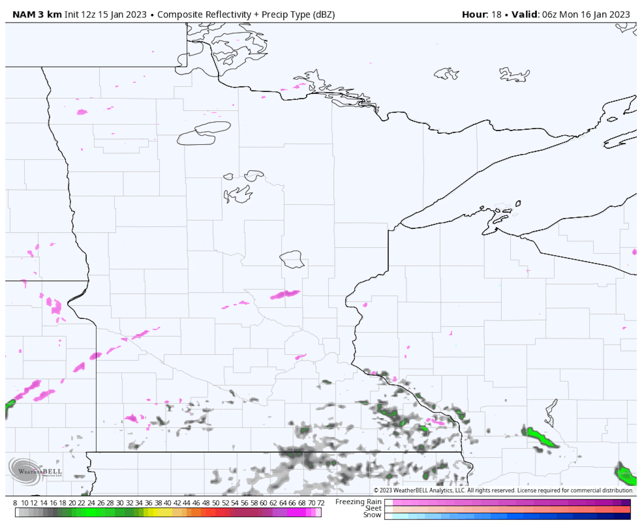
  • Precipitation will start early Monday morning as some freezing rain or an ice/snow mix across western, central, and northern Minnesota, with rain expected in south-central/southeastern Minnesota (including the metro).
  • In south-central/southeastern Minnesota, precipitation will continue as rain throughout the day. Meanwhile, farther north and west, snow will take over the ice potential... but some rain could mix in at times.
  • As we head into Monday Night, precipitation statewide will turn over to snow, lingering on Tuesday for some.

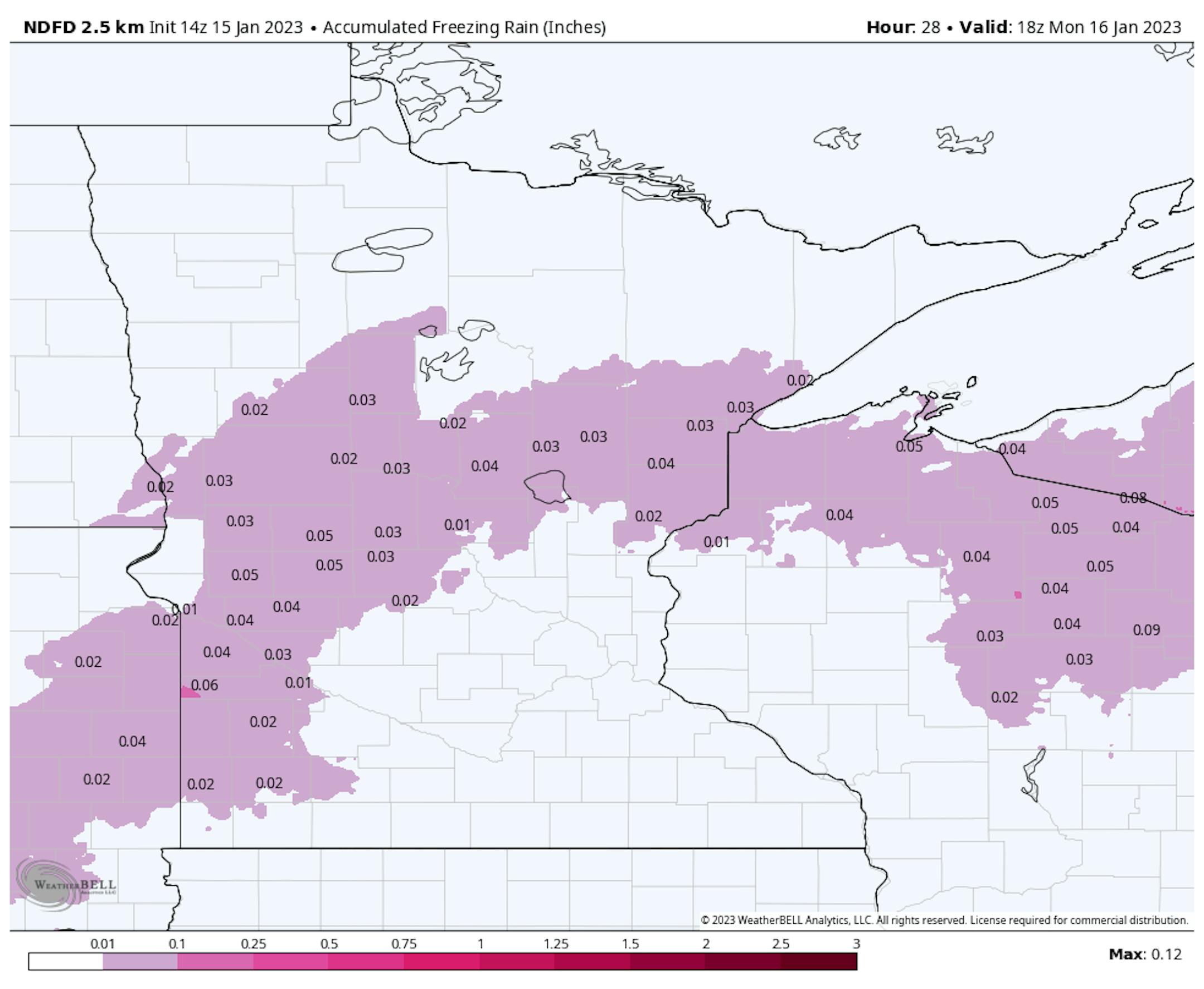
Starting off with the freezing rain chance, a glaze to about 0.05" of ice is expected from western Minnesota into parts of central/northern Minnesota. Most of that will fall through Monday morning.

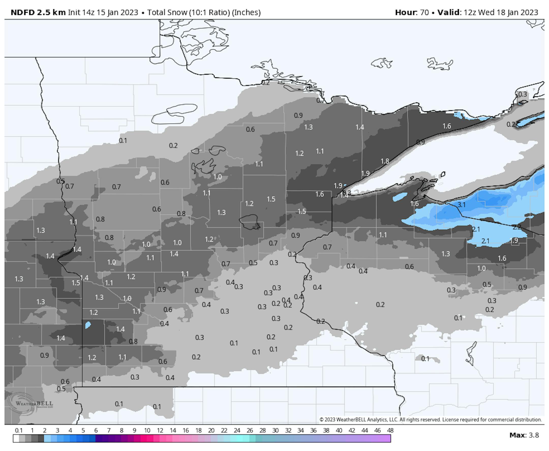
From southwestern to northeastern Minnesota, overall 1-2" of snow is expected to fall through Tuesday. After the rain changes over to snow Monday evening here in the metro, up to about a half an inch could fall.

Meanwhile, across parts of southern Minnesota, at least a quarter inch of liquid-equivalent precipitation (rain or melted snow/ice) is expected to fall.

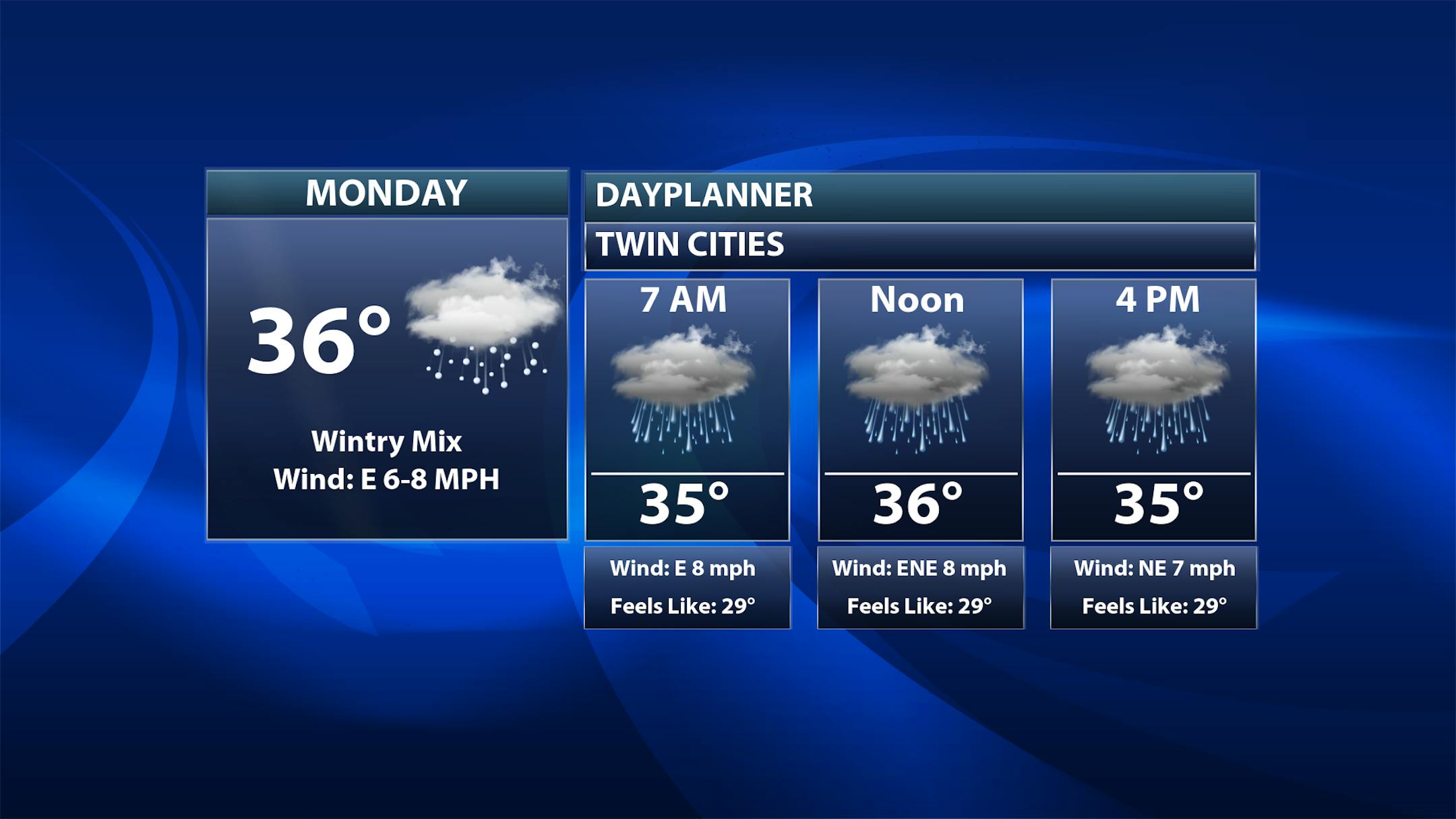
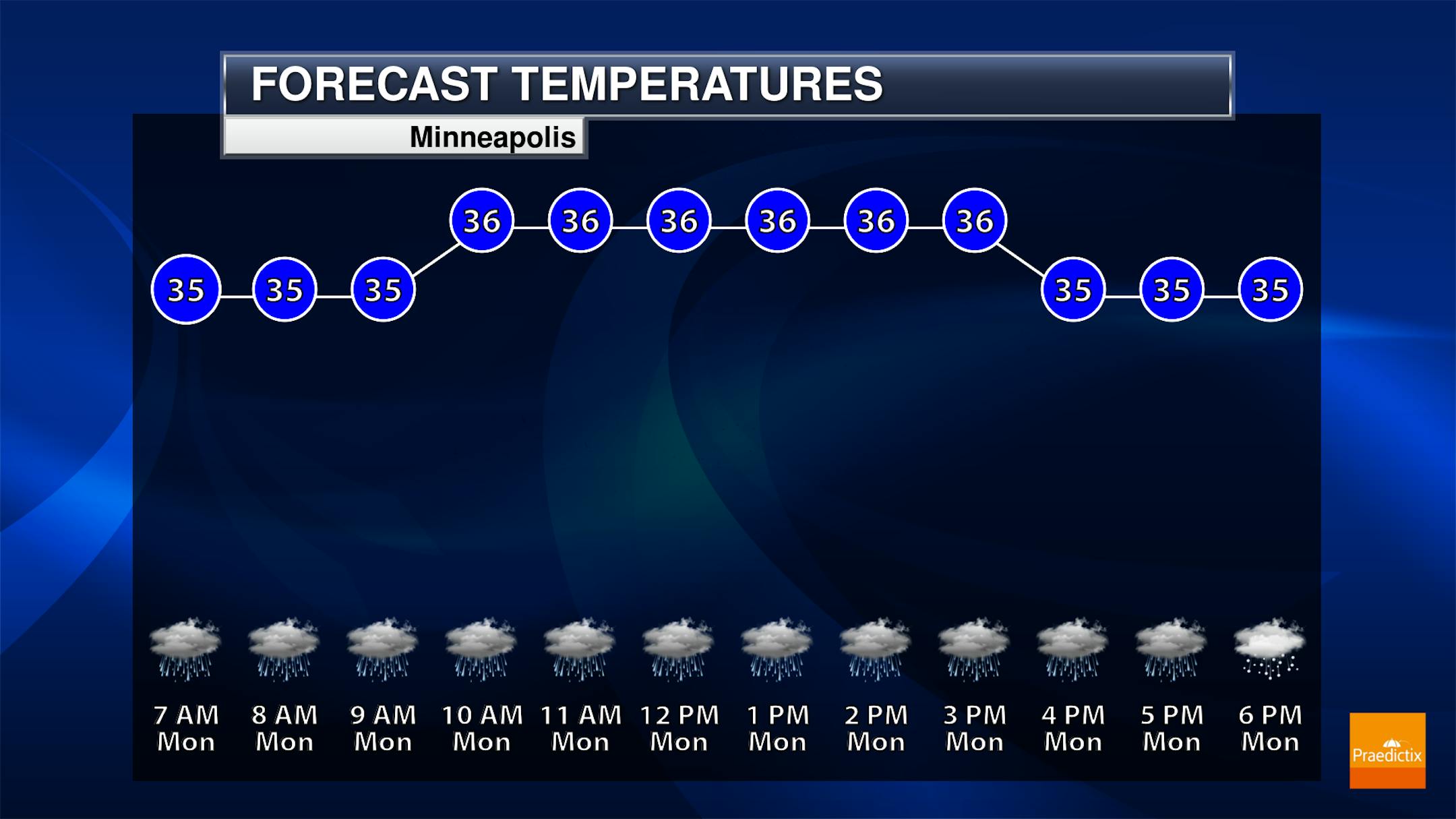
So, as mentioned above, precipitation will mainly stay in the form of rain during the day in the Twin Cities. As we head toward nightfall, however, precipitation will change over to snow. Temperatures will stay fairly steady in the mid-30s throughout the day, allowing that cold rain to fall.

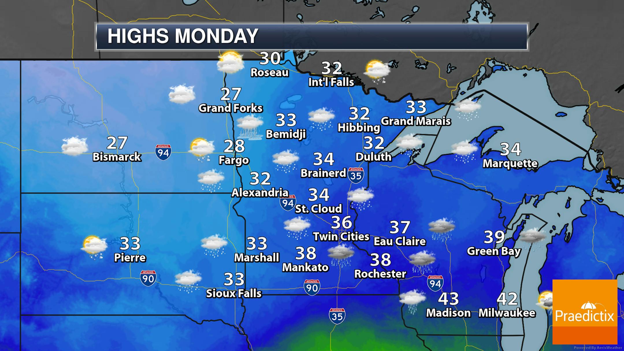
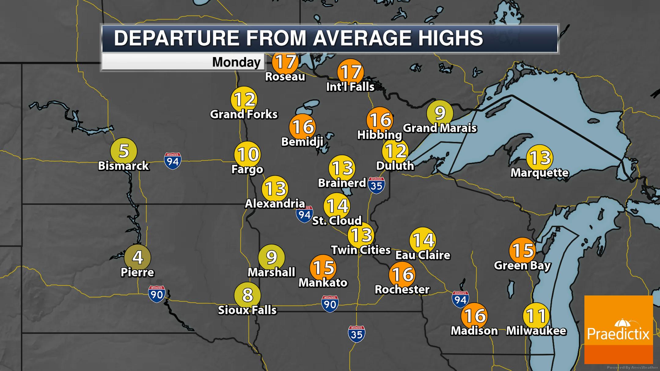
We'll keep an eye on that wintry precipitation as we head through Martin Luther King Jr. Day across the state. For western and northern areas, it'll start off as freezing rain before transitioning to snow or a rain/snow mix. In south-central/southeastern areas, it'll be in the form of rain most of the day before transitioning to snow into the overnight period. Highs will mainly be in the 30s statewide - 10-20 degrees above average.

_______________________________________________

Another Shot At Snow Thursday?

Forecast six-hour precipitation through Noon Thursday

We continue to track another storm that'll move through the Plains to the Great Lakes and Ohio Valley as we head into the second half of the week. Currently models have the greatest impacts from the storm to our south and east, but we continue to watch the potential of the northern side of the system clipping some portion of southern/eastern Minnesota into Wisconsin. Enough cold air would be in place where it would be snow falling from this system if we did see anything from it. We'll continue to track it - and its possible impacts - the next several days.

_______________________________________________

20s & 30s This Week; Cooler Toward The End Of The Month

As we head through the full third week of January here in the metro, highs are expected to remain above average in the 30s Monday and Tuesday, dipping into the 20s for the second half of the week.

While it looks like we remain in the 20s to around 30F through next week and the beginning part of the fourth week of January... the shoe looks to drop toward the last 7 days of the month with colder than average highs in the teens expected to return.

_______________________________________________

Warm But Snowy January So Far

As we are about half way through the month, lets look at the climate numbers so far. We are above average across the board!

  • The average temperature of 22.0F is the 25th warmest start to the month (through the 14th (Saturday)) - however, 2019, 2020, and 2021 saw warmer starts.
  • Just over 15" of snow has fallen - all of that fell in the first five days of the month with that strong lingering system that finally made me go buy a gas snowblower. While we have had five traces since then, that's it - just traces of snow. Our average snowfall for the entire month is 11.0".
  • That 15.1" of snow had over 1.2" of liquid in it, also putting us far above average for the month. Our average precipitation for the full month is 0.89".

_______________________________________________

If Skies Clear You Can Check Out A Green Comet
By Paul Douglas

You can wish upon a star - OR - gawk at a greenish-colored comet later this week. Comet C/2022 E3 (ZTF) - it really needs a better name - makes its closest approach to Earth on February 1 (about 26 million miles). But a new moon this upcoming Saturday may lead to the best viewing conditions. Weather permitting, of course. The comet, looking like a fuzzy star with a touch of green, should be visible in the morning sky with binoculars, possibly with the naked eye. The last time this particular comet flew past Earth was 50,000 years ago, much to the delight of our Neanderthal relatives

A cold rain today ends as an inch of slushy snow tonight. The next gently-used California storm pushes snow into the region on Thursday, and a few inches of snow may pile up. With afternoon temperatures near 30F roads may be a decent shape. Or not.

After an extended January Thaw we cool off into the teens by late month, but no arctic slaps similar to what we endured before Christmas are in sight. One day at a time.

_______________________________________________

Paul's Extended Twin Cities Forecast

MONDAY: Rain today, 1" slush late. Wake up 34. High 36. Chance of precipitation 100%. Wind E 7-12 mph.

TUESDAY: Clouds linger, flurries taper. Wake up 31. High 33. Chance of precipitation 50%. Wind NW 8-13 mph.

WEDNESDAY: Mostly cloudy and dry. Wake up 29. High 34. Chance of precipitation 10%. Wind NE 5-10 mph.

THURSDAY: Wet snow, few inches possible. Wake up 24. High 31. Chance of precipitation 70%. Wind N 10-20 mph.

FRIDAY: Cloudy with better travel. Wake up 23. High 27. Chance of precipitation 10%. Wind W 5-10 mph.

SATURDAY: A few sunny breaks. Wake up 22. High 26. Chance of precipitation 20%. Wind SW 7-12 mph.

SUNDAY: Clipper arrives, light mix north? Wake up 23. High 35. Chance of precipitation 30%. Wind SW 10-15 mph.

_______________________________________________

Minneapolis Weather Almanac And Sun Data
January 16th

*Length Of Day: 9 hours, 11 minutes, and 44 seconds
*Daylight GAINED Since Yesterday: 1 minute and 50 seconds

*When do we see 10 Hours of Daylight?: February 6th (10 hours, 1 minutes, 13 seconds)
*When is Sunrise at/before 7:30 AM?: February 3rd (7:30 AM)
*When is Sunset at/after 5 PM?: January 17th (5:00 PM)

_______________________________________________

This Day in Weather History
January 16th

1921: Winds gusting up to 59 mph create a 'sand blizzard' across southwest Minnesota and a snowstorm across the north.

_______________________________________________

National Weather Forecast

On Monday, an area of low pressure pushing through the Central United States will bring the potential of snow and ice from the Northern Plains to the Great Lakes, with showers and storms across much of the Mississippi Valley to the Mid-Atlantic. Some of the storms in the upper/mid-Mississippi Valley could be strong. Another system moving inland out west will bring additional heavy rain and heavy mountain snow. Ice and a mix of precipitation will also be possible in New England.

Heavy snow will continue to fall from the Sierra into parts of the Rockies, with feet expected. The heaviest additional rain will fall along parts of the West Coast into the Southwest, where some could see at least an additional 2-3" of rain.

_______________________________________________

How bad will 2023 tornado season be? Climate change may have fueled Alabama storms, experts say

More from AL.com: "A La Nina weather pattern, warm moist air coming from an unusually toasty Gulf of Mexico, likely juiced by climate change, and a decades long eastward shift of tornadoes came together to create the unusually early and deadly storm system that hit Alabama Thursday, meteorologists said. And it may be the start of a bad tornado year, one expert worries. Early signals, which could change, "indicate the overall pattern remains favorable for an above average tornadic year," said Northern Illinois University meteorology professor Victor Gensini, who studies tornado patterns."

The Key to California's Survival Is Hidden Underground

More from WIRED: "Water is urban planners' nemesis. Because the built environment is so impervious to liquid, thanks to all that asphalt, concrete, and brick, water accumulates instead of seeping into the ground. That's how you get the extreme flooding that has plagued California for weeks, so far killing 19 people and causing perhaps $30 billion in damages. Traditionally, engineers have treated stormwater as a nuisance, building out complex infrastructure like drains and canals to funnel the deluge to rivers or oceans before it has a chance to puddle. But in California and elsewhere, climate change is forcing a shift in that strategy. As the world warms, more water evaporates from land into the atmosphere, which itself can hold more water as it gets hotter. Storms in the Golden State will come less frequently, yet dump more water faster when they arrive. Stormwater drainage systems just can't get the water away fast enough."

The Surprising History of Climate Change Coverage in College Textbooks

More from Inside Climate News: "If you were an American college student studying biology in the 1970s, your course textbook probably contained information about standard topics like photosynthesis, cellular division, genetics and food chains. But you might also have come across something less expected, tucked in the last few pages of your book: an explanation of the greenhouse effect and what it could mean for global temperatures in the future. "​​I was really, really surprised that it had been in our textbooks for that long," said Jennifer Landin, an associate professor of biological sciences at North Carolina State University whose accidental discovery of a passage about global warming in a 1978 textbook sparked the idea to conduct a study of climate change coverage in undergraduate course materials. In the study, published in December, Landin and her co-author, Rabiya Arif Ansari, sought to understand how climate change was taught in college classrooms by analyzing 57 textbooks from the past 50 years."

_______________________________________________

Follow me on:

Thanks for checking in and have a great day!

- D.J. Kayser