2023: Most 80-Degree Days On Record

Today is the last day of 80s before the inevitable cool-down, and T-storms along the leading edge of a "reality front" may be strong tonight. After a damp start we dry out Wednesday. A second, stronger cool front arrives Thursday. By late week highs hover in the 50s with a faint whiff of wind chill. Check the blog for more details. -Todd Nelson

October 3, 2023 at 2:42AM

All-Time Record Highs For Sunday, October 1st

Hard to believe, but Sunday, October 1st was the hottest October day on record for both Minneapolis and St. Cloud!!

  • MSP reached 92F beating the old record of 90F set on October 10th in 1928 and October 3rd in 1997.
    • St. Cloud hit 91F, which beat its previous hottest October temp of 90F.
      • Eau Claire tied the all-time record of 89F.
        • Monday was another record-setting day for Minneapolis reaching 89F.
          Record Highs From October 1st (NWS Twin Cities/The Minnesota Star Tribune)

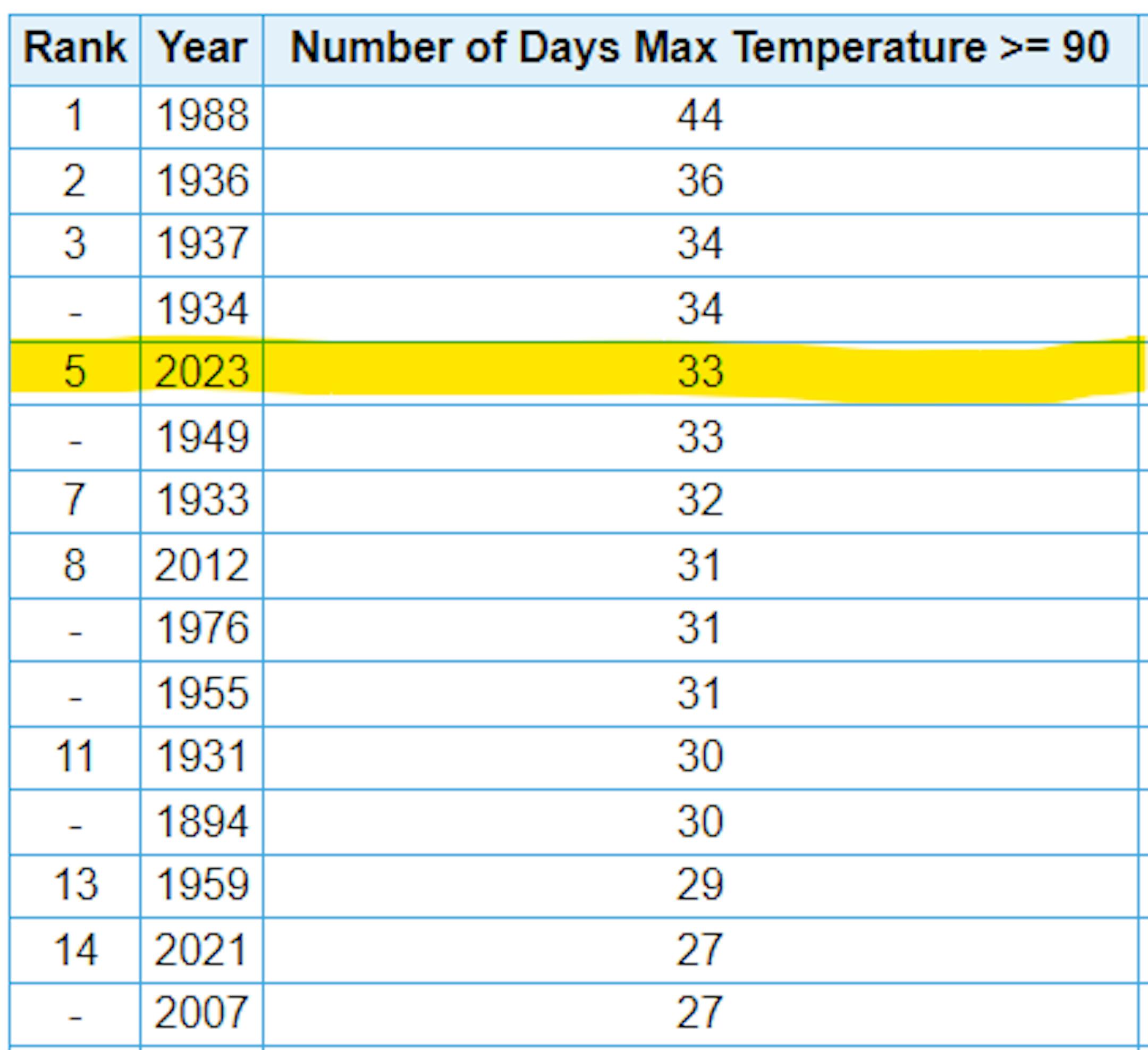
          5th Most Number of 90F Days at MSP

          MSP has now had (33) 90F days so far this year, which is tied for the 5th most number of 90F days on record. We missed another 90F day by 1F degree on Monday.

          5th Most Number 90F Days at MSP (NOAA NWS/The Minnesota Star Tribune)

          Most Number of 80F Days at MSP

          Believe it or not, we've had more 80F degree days at MSP than any other year on record. We tipped the scales on Sunday, October 1st with 99 days, but with a high of 89F on Monday, we have now had (100) 80F days so far this year. Tuesday will likely be the 101st day!

          Most Number of 80F Days at MSP (NOAA NWS/The Minnesota Star Tribune)

          90 Day Precipitation Anomaly

          Thanks to some recent heavy rains parts of the state are now in a surplus over the last 90 days. Some of the biggest surpluses (which aren't many) are showing up in blue in pockets along and north of the Twin Cities and also just east of the metro in western Wisconsin.
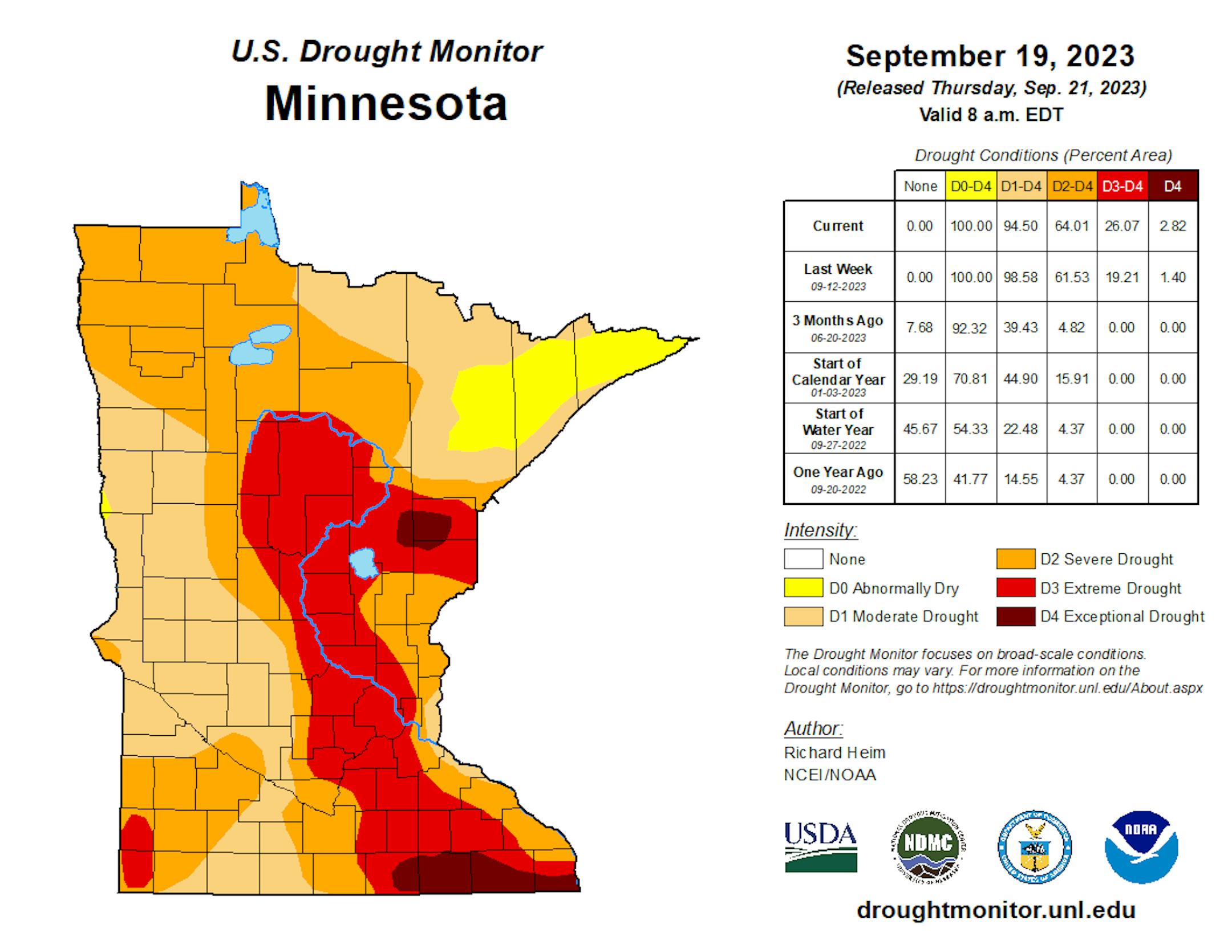
          90 Day Precipitation Anomaly (WeatherBell/The Minnesota Star Tribune)

          Drought Update

          Recent heavy rains have not yet been reported in the drought monitor updates. This is a look at last week's report, which still had nearly 25% of the state in an extreme drought. My guess is that this week's report will have lessened quite a bit of the those numbers. Stay tuned...

          Minnesota Drought Update (US Drought Monitor/The Minnesota Star Tribune)

          Fall Color Update

          Here's a picture from the Itasca State Park in late September from the DNR Staff. There were a few hints of color a couple of weeks ago, so colors should be well on their way there.

          Fall Colors (MN DNR/The Minnesota Star Tribune)

          Fall Color Update

          According to the MN DNR, the fall color season is underway and happening fast. Parts of northern Minnesota are already at peak color. Fall colors will continue to rapidly change, so take a moment and enjoy the season while you can. Note that most leaves will vacate the premises in a few weeks and won't return until sometime in mid/late May...

          Minnesota Fall Color Update (MN DNR/The Minnesota Star Tribune)

          Wisconsin Fall Color Update

          Here's a look at the fall color report in Wisconsin. Fall colors are peaking in some areas and peak isn't far away in others.

          Wisconsin Fall Color Update (Travel Wisconsin/The Minnesota Star Tribune)

          Typical Peak Fall Color

          According to the MN DNR, typical peak color arrives across the international border mid to late September with peak color arriving near the Twin Cities late September to mid October. It won't be long now and you'll be able to find your favorite fall color in a backyard near you.

          Typical Peak Colo (MN DNR/The Minnesota Star Tribune)

          Tropical Storm Philippe

          Here's a look at Tropical Storm Philippe from PM Monday, which was lingering over the eastern Caribbean Islands. Gusty winds and very heavy rainfall will continue in these areas.

          Tropical Storm Philippe From PM Monday (Tropical Tidbits/The Minnesota Star Tribune)

          Tracking Philippe

          According to NOAA's NHC, Philippe will continue to drift north over the next several days and will make a close encounter with Bermuda later this week as a Tropical Storm with gusty winds and elevated surf. Philippe could become a hurricane this weekend north of Bermuda.

          Tracking Philippe (NOAA NHC/The Minnesota Star Tribune)

          Past Peak of the Atlantic Hurricane Season

          The Atlantic hurricane season runs from June 1st to November 30th, but did you know that the typical peak is September 10th? This is when the Atlantic Basin has had the most hurricanes and named storms since records began. This is also when weather conditions are at optimal levels for these types of storms.

          Atlantic Hurricane & Tropical Storm Climatology (NOAA NHC/The Minnesota Star Tribune)

          Weather Outlook For Tuesday

          The weather outlook on Tuesday shows high temps warming into the 70s & 80s across the state, which will be nearly +15F to +25F above average for this time of the year. Duluth and International Falls could reach record levels.

          Weather Outlook For Tuesday (Praedictix/The Minnesota Star Tribune)
          Highs From Average on Tuesday (Praedictix/The Minnesota Star Tribune)

          Simulated Radar

          Twin Cities Weather Outlook For Tuesday

          The weather outlook for the Twin Cities on Tuesday, October 3rd will be another very warm day with temps warming into the low/mid 80s, which will be well above average for this time of the year. Southerly winds will be breezy with gusts approaching near 30mph at times in the afternoon.

          Twin Cities Weather Outlook For Tuesday (Praedictix/The Minnesota Star Tribune)

          Meteograms For Minneapolis

          Temps in Minneapolis will start in low/mid 60s in the morning and will warm into the lower 80s by the afternoon. Skies will be mainly dry with wind gusts approaching 30mph.

          Hourly Temps & Sky Conditions For Minneapolis on Tuesday (Praedictix/The Minnesota Star Tribune)
          Hourly Wind Gusts & Direction For Minneapolis on Tuesday (Praedictix/The Minnesota Star Tribune)

          Extended Temperature Outlook For Minneapolis

          The 5 day temperature outlook for Minneapolis shows high warming into the 80s for one more day on Tuesday before the bottom falls out to near normal levels at this time of the year. We'll see readings in the 60s on Wednesday and Thursday, but it'll be even colder on Friday and Saturday with highs only warming into the 50s.

          5 Day Temperature Outlook For Minneapolis (Praedictix/The Minnesota Star Tribune)

          Summer-like, Then Very Fall-Like Late Week

          The max dewpoint forecast for Minneapolis over the next few days shows readings in the lower 60s through midweek, which will still feel like summer. A cool front will push through midweek with falling temps and dewpoints.

          5 Day Max Dewpoint Forecast For Minneapolis (Praedictix/The Minnesota Star Tribune)

          Extended Weather Outlook For Minneapolis

          The 7 day extended outlook shows warm temps hanging on Tuesday before the bottom falls out Wednesday. We'll see readings close to average again Wednesday and Thursday before even cooler readings arrive Friday and Saturday.

          7 Day Weather Outlook For Minneapolis (Praedictix/The Minnesota Star Tribune)

          A Slight Temperature Bump Next Week

          According to NOAA's National Blend of Models, temperatures will be well above average on Tuesday with highs in the mid 80s. We'll cool down quite a bit later this week with readings dropping into the 50s by the weekend.

          NBM Extended Temperature Outlook For Minneapolis (WeatherBell/The Minnesota Star Tribune)

          Weather Outlook

          A storm system will move through the Midwest midweek with a little bit of rain and thunder. Interestingly, a reinforcing shot of cooler weather will dive into the Midwest on Friday and Saturday with a few more showers, but even cooler temps.

          National Weather Outlook Through Next Weekend (Praedictix/The Minnesota Star Tribune)

          8 to 14 Day Temperature Outlook

          According to NOAA's Climate Prediction Center, the 8 to 14 day temperature outlook shows Warmer than average temperatures across much of the nation as we approach mid month. Readings in the Midwest will most certainly remain above average average a shot of cooler weather this weekend.

          8 to 14 Day Temperature Outlook (NOAA CPC/The Minnesota Star Tribune)

          8 to 14 Day Precipitation Outlook

          According to NOAA's Climate Prediction Center, more active weather will develop across the Pacific Northwest. Meanwhile, drier weather will develop from the Plains to the Great Lakes and Northeast.

          8 to 14 Day Precipitation Outlook (NOAA CPC/The Minnesota Star Tribune)

          2023: Most 80-Degree Days On Record
          By Paul Douglas

          The trees are confused. Squirrels are dazed. I'm debating whether to rake the lawn in flip-flops or maybe take a pontoon ride? That's an easy one.

          Sunday was the hottest October day ever recorded in the Twin Cities. September was the warmest on record for the metro and statewide. For the record, we've had 33 days at or above 90F this summer; 5th most on record. Today will be the 101st day of 2023 with a high temperature above 80F in the Twin Cities; the most ever recorded. Longer growing/boating/bug season anyone? Yeah, it's getting warmer.

          Today is the last day of 80s before the inevitable cool-down, and T-storms along the leading edge of a "reality front" may be strong tonight. I expect any heavy weather to hold off until after today's Twins Wildcard Playoff Game.

          After a damp start we dry out Wednesday. A second, stronger cool front arrives Thursday. By late week highs hover in the 50s with a faint whiff of wind chill. No frost in or near the metro but keep a jacket handy. It's autumn right?

          Extended Forecast

          TUESDAY: Warm sun. Storms tonight. Winds: S 15-30. High: 82.

          TUESDAY NIGHT: Showers & storms. Breezy. Winds: SSW 15-30. Low: 64.

          WEDNESDAY: Damp start, skies brighten. Winds: W 10-20. High 70.

          THURSDAY: Breezy, mix of clouds and sun. Winds: NW 15-30. Wake-up: 57. High 64.

          FRIDAY: Raw, a few windblown showers. Winds: NW 15-35. Wake-up: 49. High 55.

          SATURDAY: Peeks of sun, less wind. Winds: NW 10-20. Wake-up: 45. High 54.

          SUNDAY: Milder with more sunshine. Winds: W 8-13. Wake-up: 42. High: 62.

          MONDAY: Plenty of sunshine, pleasant. Winds: W 8-13. Wake-up: 44. High: 65.

          This Day in Weather History

          October 3rd

          1999: The earliest ever single digit temperature in Minnesota is recorded at Embarrass, with a low of 9.

          1922: A hot fall day occurs in Minnesota. Notable highs are 95 in Ada and 93 at Moorhead.

          Average High/Low for Minneapolis

          October 3rd

          Average High: 65F (Record: 90F set in 1997)

          Average Low: 47F (Record: 26F set in 1996)

          Record Rainfall: 2.62" set in 1903

          Record Snowfall: Trace set in 1935

          Twin Cities Almanac For October 2nd (Praedictix/The Minnesota Star Tribune)

          Sunrise/Sunset Times for Minneapolis

          October 3rd

          Sunrise: 7:13am

          Sunset: 6:50pm

          Hours of Daylight: ~11 hours & 37 minutes

          Daylight LOST since yesterday: 3 Minutes & 5 Seconds

          Daylight LOST since Summer Solstice (June 21st): ~ 4 Hour & 00 Minutes

          Moon Phase for October 3rd at Midnight

          2.3 Day Before Last Quarter Moon

          2.3 Day Before Last Quarter Moon (The Minnesota Star Tribune)

          National High Temps on Tuesday

          Temperatures on Tuesday will be warmer than average across the eastern half of the country with record warmth possible from the Great Lakes to the Northeast. Cooler than average readings will be found in the Intermountain-West.

          National Weather Outlook For Tuesday (Praedictix/The Minnesota Star Tribune)
          National Highs From Average on Wednesday (Praedictix/The Minnesota Star Tribune)

          National Weather Tuesday

          The weather outlook on Tuesday looks unsettled Across much of the Central US with scattered showers and storms, some of which could be strong to severe with locally heavy rainfall. There will also be areas of rain and snow across the northern rockies.

          National Weather Map For Tuesday (Praedictix/The Minnesota Star Tribune)

          National Weather Outlook

          The weather outlook through Thursday shows unsettled weather across the Central US with scattered showers and storms, some of which could be strong to severe with locally heavy rainfall.

          National Weather Outlook Through Wednesday (NOAA WPC/The Minnesota Star Tribune)

          Extended Precipitation Outlook

          The extended precipitation outlook shows areas of heavy rainfall across the Southern US with several inches of rain possible across Oklahoma and Texas. There will also be areas of heavy rain in the Northeast, but the Desert Southwest will remain dry.

          Extended Precipitation Outlook (NOAA WPC/The Minnesota Star Tribune)

          Climate Stories

          (NOAA/The Minnesota Star Tribune)

          "Astronomers have noctalgia (sky grief), or sadness at the loss of dark skies"

          "Noctalgia (sky grief) As human population has increased, and as artificial lights have spread across Earth, the stars have been disappearing. And now astronomers have proposed a new word to describe their sadness over the loss of dark nights. The word they propose is noctalgia (sky grief), from an earlier word solastalgia, the lived experience of negatively perceived environmental change (with noct being a root word meaning night). In a late August 2023, in an open letter to the journal Science (pdf here), astronomers Aparna Venkatesan of the University of San Francisco and John C. Barentine of Dark Sky Consulting wrote: Our diminishing ability to view the nighttime sky due to rapidly rising human-made light pollution is part of the palpable keening [a loud wailing or lament] of all that is passing each day. We offer here the term noctalgia to express 'sky grief' for the accelerating loss of the home environment of our shared skies, a disappearance felt globally and deserving its own field of study of 'nyctology' [the study of night matters]."

          "A Revelation About Trees Is Messing With Climate Calculations"

          "EVERY YEAR BETWEEN September and December, Lubna Dada makes clouds. Dada, an atmospheric scientist, convenes with dozens of her colleagues to run experiments in a 7,000-gallon stainless steel chamber at CERN in Switzerland. "It's like science camp," says Dada, who studies how natural emissions react with ozone to create aerosols that affect the climate. Clouds are the largest source of uncertainty in climate predictions. Depending on location, cloud cover can reflect sunlight away from land and ocean that would otherwise absorb its heat—a rare perk in the warming world. But clouds can also trap heat over Arctic and Antarctic ice. Scientists want to know more about what causes clouds to form, and if that effect is cooling or heating. And most of all, says Dada, "We want to know how we humans have changed clouds."

          "How rumors and conspiracy theories got in the way of Maui's fire recovery"

          "After the wildfires in Lahaina on the Hawaiian island of Maui last month, unsubstantiated rumors and conspiracy theories spread nearly as fast as the flames had. There was the one about the government — in some versions it was the U.S., in others a foreign government — using energy beam weapons to start the fire. Others blamed Oprah, the wealthy media mogul, and falsely claimed she was making a land grab. Still others claimed the fires were a cover-up for military malfeasance. Lahaina residents told NPR reporters on the ground that the rumors were spreading fear and confusion at a vulnerable time. On a visit to Danilo Andres' home in the burn zone — miraculously standing after the fires — Andres says there was talk that the homes left standing might be further targeted: "There's a satellite in the sky, they just pinpoint the house," he said, explaining the theory. "The rumor's in the hotel right now, so everybody's moving out."

          Thanks for checking in and don't forget to follow me on Twitter @TNelsonWX

          @TNelsonWX (The Minnesota Star Tribune)
          about the writer

          about the writer

          Todd Nelson

          See Moreicon