
Fantastic Displays of Rime Ice
Freezing fog over the weekend created more beautiful displays of rime ice. According to NOAA's NWS, here's the definition of Rime Ice: An opaque coating of tiny, white, granular ice particles caused by the rapid freezing of supercooled water droplets on impact with an object.

Lake Superior Ice Coverage
Here's the latest ice coverage for Lake Superior from NOAA's GLERL. Note that the current ice coverage is only 1.4%. Keep in mind that at this time last year only 0.5% of the lake was covered in ice. Interestingly, this is below the long-term average (1973-2020), which typically should be around 15% ice coverage now. Also note that we typically don't see the maximum ice coverage until around the end of February or early March. It appears that we have some cold air arriving during the back half of January, so we'll see how the ice coverage changes over the coming weeks.

Lake Superior Average Ice Coverage vs Current

Current Great Lakes Ice Coverage
Here's the ice coverage across the entire Great Lakes, which currently stands at 3.1%. Last year at this time was only at 1.8%. A lack of cold air so far this season has kept the Great Lakes ice coverage at a minimum, but we'll see how that changes as we head toward the back half of January as colder air moves in.

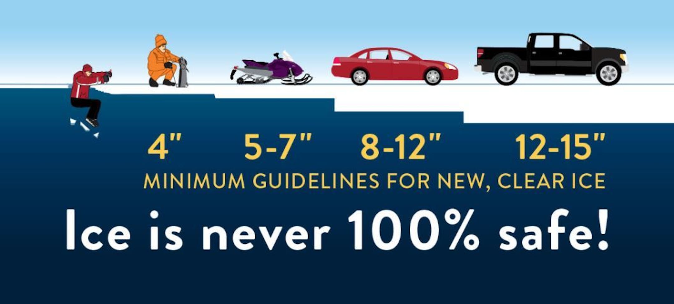
Ice Safety Guidelines
We're starting to see more folks venture out on frozen lakes and ponds across the state and region, but keep in mind that that ice is never 100% safe!! You need at least 4" of ice to safely walk and close to a foot (12") to drive a small car on the ice. Stay safe out there!!
Weather Outlook Through AM Wednesday
Here's the weather from AM Monday to AM Wednesday. Other than a brief shot of light precipitation across the Arrowhead of MN, much of the region will continue to stay dry through midweek. Looking ahead, our next best chance of precipitation will arrive on Thursday in advance of cooler air that will settle in on by the weekend.

Minneapolis January Summary So Far
Here's a look at the January number so far and the first week of the month has really been warm and dry. Temps have been running nearly +6F above average, which is the 12th warmest January on record. We've also only had a trace of snowfall, which is nearly 3.5" below average so far for the month.

Snow Depth As of January 9th
Thanks to heavy snowfall during the month of December, we are still carrying a decent snowpack across the state. As of January 9th, there was still 8" of snow on the ground in the Twin Cities, International Falls and Marquette, MI.


