A tornado was reported in southeastern Minnesota on Wednesday and, if confirmed, would be the state's first ever in December, on a day of wild and unprecedented weather.
The National Weather Service has never issued a severe thunderstorm warning for Minnesota in December, let alone tornado watches and warnings. But at 8 p.m., the weather service reported a tornado in Eyota, east of Rochester, as the storm moved toward Wisconsin. Crews will survey damage Thursday to confirm the tornado.
"If you had told me that we would have a tornado watch in Minnesota 10 days before Christmas, I'd say you're nuts. You're watching the science fiction channel, not the Weather Channel," said baffled meteorologist Paul Douglas, who had been monitoring the unprecedented weather since 4 a.m. Wednesday.
The gusty winds out of the west continued to blow overnight in southern Minnesota, leaving icy conditions in many places that refroze. The wind will lessen this morning with sunny skies possible this afternoon.
Just before 7 last night, Douglas said storms were moving into Minnesota, with severe storm warnings in far southern Minnesota and lightning visible in the southwest Twin Cities metro area.
The small community of Hartland, in Freeborn County, might have been the hardest hit, county Emergency Management Director Rich Hall said. About 35 to 40 homes sustained minor damage while a few businesses along Broadway were severely damaged. Several barns were down and roofs were blown off some sheds, he added.
Hall said none of the 300 or so Hartland residents were reported injured but crews were limiting traffic because it was dangerous with downed power lines. He said many residents were without power and they were working to get that restored late Wednesday night.
In Dodge County, Sheriff Scott Rose reported trees and power lines down throughout the county.
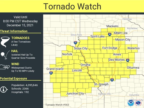
The historic tornado watch, which was canceled by 10 p.m., spanned the southern part of the state north to the Twin Cities, according to the weather service. Parts of Illinois, Iowa and Wisconsin, including La Crosse and Eau Claire, were included in the watch.
Isolated hail was possible, along with widespread gusts up to 90 mph. The weather service warned people to prepare to seek shelter in the lowest floor of a sturdy structure if a warning was issued.
Douglas hoped residents would take the unseasonable warnings seriously. It's surreal, he added, to be faced with a tornado watch when just last week 20 inches of snow hit parts of the metro.
By 8 p.m., tornado warnings were issued in Winona and southeastern Minnesota, and by 8:15 p.m., Xcel Energy reported 61 power outages in Minnesota affecting about 4,900 customers, mostly in the south and southeast parts of the state.
Freeborn County in far southern Minnesota was in the heart of the state's tornado watch. Hall was quoting Jimmy Buffett early Wednesday evening when, following a Zoom meeting with first responders, highway department and Homeland Security crews, he said there was no "trying to reason with a hurricane season."
But he said that's not what anyone would ever expect from Minnesota in winter. Hall said the scale of weather severity in the county had neared levels rarely reached even in the summer.
"For it to be that high in December, we're taking this threat very seriously," he said.
Douglas urged Twin Cities residents to cancel nonessential evening plans and stay aware despite not being "in a tornado frame of mind" this time of year.
"Please do have a way to get weather warnings," said Caleb Grunzke, a meteorologist with the National Weather Service in Chanhassen. "Storms will be moving very fast and you won't have much time to react."
That was the case last week, Douglas said, when people in Kentucky and the surrounding region got warnings that tornadoes were moving in fast but at least 88 were killed by the twisters that slammed six states.
Early in the evening Wednesday, a tornado was confirmed in western Iowa. The Johnson Police Department north of Des Moines reported downed trees taking out street lights and tin roofing landing in the roadway. The Des Moines Register reported overturned semis along the interstate as well.
In Minnesota, the day started out with pockets of dense fog. By day's end the area experienced everything from record warmth to heavy rainfall, fierce winds and snow — all within a few hours.
Minnesota has not seen severe weather in December since .75 inch hail stones fell on Dec. 5, 2001, again in Eyota, said Pete Boulay of the state Climatology Office. And the state has never seen a tornado in the last month of the year, though records go back only to 1950, Grunzke said.
The Twin Cities broke the high temperature record for Dec. 15 — 51 degrees set in 2014 — at 2 p.m. when the weather service reported 52 degrees.
Travel will be dangerous into early morning, Hall said.
Minneapolis Public Schools informed families that potentially icy roads Thursday morning may make it necessary to move to e-learning, but the district hadn't canceled in-person classes as of 8:30 p.m.
A dusting of snow was possible in the Twin Cities, Grunzke said.
The rest of the week will be cold, quiet and more December-like with highs in the 20s and lows in the teens, Grunzke added.
In Douglas' 41 years of meteorology in Minnesota, he said he's never experienced weather like Wednesday's.
"As far as the atmosphere is concerned, it's late April, early May," he said. "It's an example of weather weirding, weather whiplash, and we're seeing more of that over time."
Staff writer John Reinan contributed to this report.
Body camera video shows Minnetonka man shooting at deputies several times before dying in firefight

Charge: Driver going 77 mph ran red light, fatally hit man crossing St. Paul street and kept going
Minnesota Senate GOP files ethics complaint against Sen. Nicole Mitchell

High school archer focuses on target: another national championship