Paul Douglas
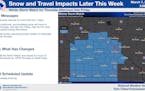
More Snow This Weekend With 2-5" For The Metro And Higher Tallies Up North
Sick of the snow yet? Well... bad news. More snow is on the way for the weekend. Snow will fall across northern Minnesota both Saturday and Sunday, with the best chance in the metro Saturday afternoon and evening. Click for more details. - D.J. Kayser
Paul Douglas
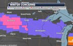
Break In The Snow Friday - More Likely Saturday Into Sunday
Snow continues Thursday Night, but we should see dry (and cloudy) skies for Friday. A clipper moves in for the weekend, bringing more snow chances along with it. The heaviest with that will fall from St. Cloud northward, where 6"+ is possible. - D.J. Kayser
Paul Douglas
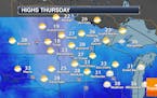
At Least 2-6" Of Snow Across Central And Southern Minnesota Thursday Into Early Friday
Getting tired of snow? We've got two more systems on tap as we head through the next few days: 2-6" for the metro Thursday into early Friday, and a clipper that'll bring 2-5" Saturday into Sunday. Getting closer to a top five snowiest winter... - D.J. Kayser
Paul Douglas
California Continues To Export Big Storms
This next system looks less impressive than it did earlier in the week. Light snow arrives later today with heavier snowfall late Thursday into Friday morning. 3-6" may fall, with the best chance of 6" over the I-90 corridor. A clipper drops more snow Saturday PM into Sunday morning, when another 2-4" may pile up. Anything over 85" at MSP means a Top 5 winter snowfall. Check the blog for more details. -Todd Nelson
Paul Douglas
What Else - More Snow Coming
At 74.7" in the metro area this is now the 13th snowiest winter since 1884. But wait, there's more! Another long-duration snow event is likely Wednesday night into Friday morning. It looks plowable, with more than 6"possible, followed by a few more inches of slush on Sunday. Check the blog for more details. -Todd Nelson
Paul Douglas
Winter Weather Advisory Through Midday Monday - Additional Snow Second Half Of The Week
2-5" of wet, slushy snow is expected across central & southern Minnesota and along the North Shore Sunday Night into Monday, causing issues for the Monday morning commute. More snow is expected for the second half of the week. - D.J. Kayser
Paul Douglas
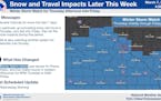
More Significant Snow Brewing Next Week
After a quiet Saturday, models hint at 2-4" Sunday, and another 2-4" Monday. It's early, but models hint at a massive storm stalling over the Great Lakes next weekend. This could turn into another long-duration snow event, with significant snowfall accumulation here at home. If you're traveling you'll want to stay up on the very latest outlook. Check the blog for more details. -Todd Nelson
Paul Douglas
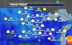
Cloudy Through Saturday - Rain/Snow Possible Sunday Into Monday
Mainly cloudy conditions continue for the next few days here in the metro with highs around average. A messy system works in Sunday and Monday, though, bringing rain and snow chances. - D.J. Kayser
Paul Douglas
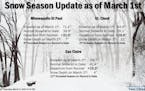
Quieter Weather Through Saturday - Top 5 Snowiest Meteorological Winter On Record
After Wednesday's snow we'll see a quiet end to the rest of the week with a sun/cloud mix to mainly cloudy skies and highs in the 30s. Next precipitation chance moves in Sunday. Click for more details as well as a look back at February and meteorological winter. - D.J. Kayser
Paul Douglas
Prepare For A Meteorologically Manic March
Exhibit A: today's storm system may drop 1-3" on the Twin Cities metro, with more snow the farther north you go - maybe a stripe of 3-5" from Alexandria to St. Cloud and Taylors Falls. Skies clear Thursday with warming temperatures near 40F by Saturday. Check the blog for more details. -Todd Nelson
Paul Douglas
Minor Slushy Snow Event on Wednesday
I see a nuisance snowfall tonight and Wednesday, maybe 1-2", more north. I see 30s for highs through next week and no dread-inducing polar fronts in sight. Check the blog for more details. -Todd Nelson
Paul Douglas
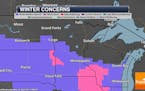
Messy start to Monday; another midweek snow chance
We're tracking ice, rain, and snow as we head though Sunday Night into Monday, with the potential of 0.1-0.25" of ice across central Minnesota into central Wisconsin. Click through for more details on how this could impact your morning commute. - D.J. Kayser
Paul Douglas
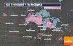
Quiet Sunday - Watching Ice, Rain & Snow For Sunday Night Into Monday
A mainly sunny Sunday is expected with highs in the mid-30s in the metro. However, we watch a system that'll bring in freezing rain, plain rain, and snow chances Sunday Night into Monday across the state. - D.J. Kayser
Paul Douglas
Sunny Weekend With Warming Temps - Wintry Mess Possible Sunday Night & Monday
After some light snow Friday Night, we'll see mainly sunny weather this weekend with highs in the mid-20s on Saturday and mid-30s Sunday. We'll watch our next system Sunday Night into Monday bring wintry precipitation to the region. - D.J. Kayser
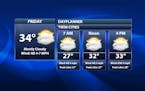
Paul Douglas
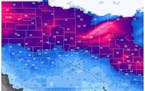
Cold Friday With A Light Snow Chance Late - Warmer Weekend
We'll see a mix of sun and clouds Friday with a chance of light snow late in the day. Sunnier and warmer weather awaits for the weekend. However, we watch a system late Sunday into Monday that'll bring mixed wintry precipitation, including potentially freezing rain. - D.J. Kayser
Paul Douglas
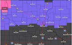
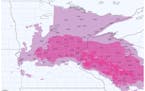
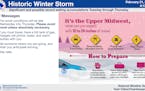
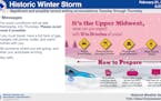
Phase Two Of Winter Storm/Blizzard Continues Into Thursday
We're watching phase two of the winter storm impacting the state Wednesday Night into Thursday, and snow totals between the two phases should be in the 10-18" range. Colder temperatures are expected Friday before a weekend warm up. - D.J. Kayser
Paul Douglas
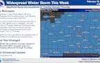
Sizing up the major winter storm, lasting until Thursday
Two primary rounds of snow are expected, with the second more widespread.
Paul Douglas
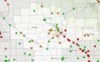
Biggest Metro Snowstorm Since 2010?
NOAA predicts a "Category 5" winter storm for the MSP metro Thursday, which means extremely dangerous or impossible driving conditions, and extensive and widespread closures. Good times. Check the blog for more details. -Todd Nelson
Paul Douglas
Light snow Monday with much more likely midweek
Total snow accumulations of greater than 12 inches possible.
Paul Douglas
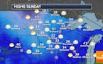
Snowy Scenes Will Return This Week
A quiet Sunday for the metro is ahead. However, we will watch a clipper for Presidents' Day Monday which will bring about an inch of snow for the metro and 2-5" from Fargo to the North Shore. Then a potentially potent system is on deck in the Tuesday-Thursday timeframe. - D.J. Kayser
Paul Douglas weather
Weather forecasts and musings from Star Tribune meteorologist Paul Douglas.