Regional Weather

Cosmetic Snowfall Likely Later Today
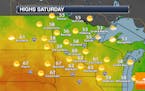
PM Saturday's clipper will fall somewhere between nuisance and plowable, with an inch south metro and as much as 3" north metro. Heaviest amounts should fall north of I-94, but there's a good chance most of us will awake to snow covered lawns Sunday morning. Check the blog for more details. -Todd Nelson
Paul Douglas
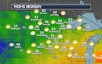
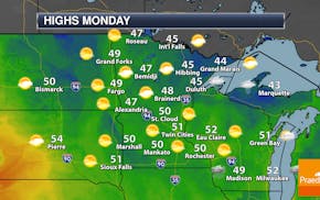
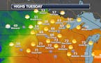
Quiet Monday With Highs In The 50s - Larger Storm System Looms Later In The Week
Monday will feature a mix of sun and clouds with highs climbing into the mid/upper 50s in the metro. However, we continue to keep an eye on a system later this week which will bring the state some rain and - in some areas - the potential of accumulating snow. Click for more details. - D.J. Kayser
Paul Douglas
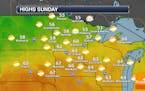
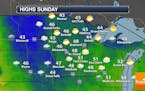
Highs Almost 20F Degrees Above Average Sunday - Precipitation Expected Late Week
Another quite warm early November day is on tap Sunday, with highs across the state in the 50s and 60s. The other shoe starts to drop, through, during the week with cooler highs returning and the chance of rain (maybe even some snow?) for the second half of the week. Click for more. - D.J. Kayser
Paul Douglas
Warm, Mainly Sunny November Weekend For The Deer Opener
It'll be warm for the Minnesota Deer Opener this weekend across the state under mainly sunny skies for most. A few showers will be possible across northern Minnesota Friday Night, lingering into early Saturday in the Arrowhead. Otherwise we watch another system toward the middle and end of next week with a better precipitation chance. Click for more. - D.J. Kayser
Paul Douglas
October Flashback This Weekend - Slush Potential Late Next Week?
It will snow. It will get cold. There will be wind chill. But not in the near term: winter is still on indefinite hold with weekend temperatures at or just above 60F, some 15-20F milder than average. We do cool off next week and a late week storm may end as slushy snow event a week from Friday, with a potential for accumulation, especially north/west of MSP. Details are sketchy (ie: unknowable) but at some point there WILL be a meteorological reality check.
Paul Douglas

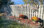
A Raging Fear of Green Lawns in November
Lake effect snows give way to a late September-like ridge of high pressure this weekend, a bubble of unusually mild, Pacific air. That should mean 50s this weekend with a chance of low 60s early next week. Check the blog for more details. -Todd Nelson
Paul Douglas
Dark Days But No Wintry Smacks
Winter is still largely AWOL east of the Rockies. In fact this is as cold as it's going to be anytime soon. Big, sloppy storms detour well south of Minnesota, while a temperate Pacific flow dominates. Models hint at 60F early next week and NOAA's GFS guidance shows a few 50s into the third week of November. Check the blog for more details. -Todd Nelson
Paul Douglas

Remembering A Very Extreme Winter Storm
Today feels like September with an outside shot at 60F in the metro later on. Halloween will feel like late October, with scrappy clouds and a chilly breeze, with Trick or Treat temperatures in the low 40s, so extra layers make sense. Check the blog for more details. -Todd Nelson
Paul Douglas

Drying Out With a Fine Fall Weekend - Slushy Possibilities Emerge Next Week
Winter has been delayed by a few weeks, but it's still coming, and Old Man Winter may fire a first shot across the bow the latter half of next week with enough cold air in place for flurries by midweek. No Halloween blizzards this time around, but by next week there will be no doubt in your mind that it's November.
Paul Douglas
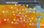
Quiet, Sunny Monday - Heavy Rain Expected Mid-Week
Fairly nice weather is expected Monday, with mainly sunny skies and highs within a few degrees of average. We're still watching rain chances as we head into the mid-week time frame, with the potential of over one inch of rain for some. Click for more details. - D.J. Kayser
Paul Douglas
Showers Across Southern Minnesota Sunday - Better Rain Chance Mid-Week
A system to our south will help bring some showers across southern Minnesota Sunday, but rain chances remain highest south of the metro. A better rain chance statewide will arrive toward the middle of the week. Click for more details. - D.J. Kayser
Paul Douglas
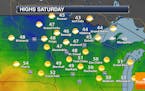
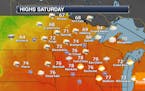
Near 50F This Week - Sunny Saturday, Wetter Sunday
Another nice autumn day awaits on Saturday as highs climb to around 50F with mainly sunny skies. Some rain will be possible for the second half of the weekend. Click for more details. - D.J. Kayser
Paul Douglas

Frost On The Pumpkin - Cool Smack But No Arctic Punches In Sight
If you have some plants you want to keep around a little longer consider covering them up, bringing them indoors, or writing them off until spring of '22, because most of Minnesota will experience a frost/freeze this morning, again Saturday morning, before temperatures moderate again next week. The drought continues to ease, with more rain in the forecast. Temperatures moderate a bit next week - relative warmth forecast to spill into early November.
Paul Douglas
Warm Tuesday - Cooler Weather To End The Week
Another warm autumn day is expected Tuesday before a mid-week system brings rain and cooler air. Highs will be closer to average in the low to mid-50s from Thursday through the weekend. Click for more details. - D.J. Kayser
Paul Douglas
Mild Autumn Weather To Begin The Week
Milder fall weather returns for the beginning of the week, with highs in the 70s Monday and Tuesday. A rainy system Wednesday helps drive cooler air back in late this week into the weekend and potentially the first frost of the season for the metro. Click for more - D.J. Kayser
Regional Weather

Mild & Sunny Sunshine. Picture Perfect For October
Our picture perfect October weekend continues. If yesterday wasn't good enough, today will be even better! Highs across the state will warm to nearly 10 degree above average levels with bright sunshine and near peak fall color. Enjoy! Check the blog for more details. -Todd Nelson
Paul Douglas

Cool Crisp Sunshine With Slow Warming Trend Into Monday
It's been so mild for so long that "average temperatures" are now described as a "cold front". That's where we are. A steady breeze should reduce the risk of a frost or freeze for much of central and southern Minnesota, and a rerun of southerly winds should mean daytime highs close to 70F Sunday and Monday before another inevitable cooling trend next week. The pattern isn't ripe for big storms anytime soon.
Paul Douglas
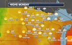
Mainly Cloudy Monday - Strong Storm System Mid-Week
Skies across the metro will be mainly cloudy Monday as we watch a system pass off to our east. We're keeping our eyes on a wet, windy system for mid-week. - D.J. Kayser
Regional Weather

A Long Slow Slide Into Autumn This Year
Instability showers linger today and although the brunt of Monday's rain stays over Wisconsin, we may be brushed by a shower. Wednesday's storm may spark gusts as high as 40-50 mph, with a quick slug of heavy rain. It will feel like October by late week, with a shower spilling into Saturday, Check the blog for more details. -Todd Nelson
Paul Douglas
Partly Sunny Saturday As Highs Climb Near 80F - Storms Saturday Night Into Sunday
We'll see partly sunny skies on Saturday as highs climb up to near 80F - potentially our last 80F of the year! After that, storms will move in Saturday Night into Sunday, some of which could be severe. A couple more rain chances are in the forecast next week. Click for more details. - D.J. Kayser
Paul Douglas weather
Weather forecasts and musings from Star Tribune meteorologist Paul Douglas.
