While Gov. Mark Dayton headed south Saturday to inspect the heavily flooded southern Minnesota town of Waterville, rain-weary residents in the Twin Cities braced for more storms overnight and into Sunday.
The National Weather Service in Chanhassen said the Twin Cities and south-central Minnesota could get 1 inch to 2 inches of rain by the end of Sunday, with heavier rain and chances of hail and tornadoes from Mankato to Albert Lea.
"The metro area will be on the lower end of that," said Chris Franks, a meteorologist with the Weather Service.
By Saturday afternoon, however, heavy rains and strong winds had already moved into the metro, prompting the Twin Cities Jazz Festival to cancel shows in St. Paul's Mears Park Saturday evening and move most of those performances indoors, event officials said.
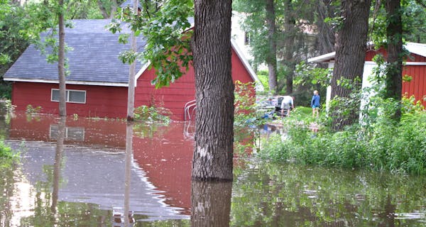
In flooded Prior Lake, Mayor Kenneth Hedberg said he was "absolutely relieved" that Saturday afternoon rains raised the water levels by only a quarter-inch. But "they are still forecasting another one to two inches tonight and that would create additional problems for us. The waters are rising" and 40 homes are already flooded," he said. More rain could be "catastrophic."
This is the wettest year on record for the Twin Cities, with more than 25 inches of precipitation since Jan. 1 — nearly 12 inches above normal. It's the second wettest June on record.
But while the rain may feel repetitive, experts said that it shouldn't send rivers and creeks rising again, but rather, would slow receding floodwaters. They were concerned, however, that the weekend storms could pack powerful winds. With the ground already saturated, trees can easily be uprooted by high wind. Similar conditions brought down dozens of trees across the metro two weeks ago.
Sunday should be dry for early events such as farmers markets and Twin Cities Pride. Storms are expected after 3 p.m. in the metro.

Marijuana's path to legality in Minnesota: A timeline
Minnesota to close state park on Iron Range, turn it back into a mine
U.S. Steel won't get exception to pollution rules that protect wild rice, MPCA says

Taste of Minnesota to be enjoyed on the ground and in the air this year