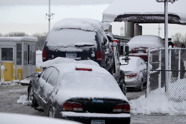
The Minnesota State Patrol on Friday warned drivers to park their vehicles this weekend after heavy snow and ice left roads in miserable — and potentially deadly — condition across the eastern half of Minnesota and western Wisconsin.
Standing near sun-drenched Interstate 94 and Hwy. 280 in Minneapolis, where semitrailer trucks struggled to get a grip, Patrol Lt. Eric Roeske said, "We want to stress that not only should people not travel [Friday], but these conditions will not be getting much better this weekend" because of strong winds and plummeting temperatures that will preserve potentially lethal stretches of ice.
"If you don't absolutely need to travel through the weekend, don't do it," he said.
From 2 p.m. Thursday to 6 p.m. Friday, the state patrol responded to 685 crashes in the metro area alone, as well as nearly 2,000 spun-out or off-the-road vehicles, 66 semitrailer truck jackknives and 809 stalled vehicles. Metro Transit reported at 6 p.m. that 60 percent of its buses were running behind schedule, with an average delay of 12 ½ minutes.
Metro commutes through the day ran about triple the normal time, said Minnesota Department of Transportation (MnDOT) information officer Don Zenanko. While conditions improved somewhat during the day, the afternoon rush hour was still plagued by trucks struggling up ramps and other inclines, as well as crashes and stalled vehicles. Streets and highways washboarded with ice and compacted snow made driving a slow shimmy-shake.
"I'd rate it at 12. It's off the charts," Zenanko said. "It's been one of the more challenging days I've had in 20 years of watching traffic."
Patrol Lt. Col. Matt Langer said the patrol is "receiving reports from veteran troopers in several areas of the state of conditions that are as bad as they've seen in 25 years. It is simply too dangerous right now, and MnDOT needs room to clear the roads of snow and ice."
The new snow in the Twin Cities — 9.9 inches for the official total at Minneapolis-St. Paul International Airport but 11 inches at Elk River and other suburbs — promptly froze atop rain and slush that fell Thursday on highways and freeways, quickly becoming packed and icy.
Across southern Minnesota, dozens of highways were closed, including parts of I-90 and I-35. Those reopened Friday, but Friday night MnDOT was still describing a broad wedge of highways from St. Cloud and Duluth through the Twin Cities to the Iowa border as hazardous. Much of the rest of the state's roads were said to offer "difficult" driving.
"It may take a day or two" for much of the Twin Cities highway system to be pretty much clear of ice and those rutty ridges of snow, said MnDOT spokeswoman Christine Krueger. "We need to give the chemicals time to work, and hopefully, we'll get some help from the sun to warm up the road surface."
Late Friday morning, Gov. Mark Dayton declared a state of emergency and directed the Minnesota National Guard to assist any stranded motorists in the state's snow-burdened regions.
Elsewhere in the state, points north and east of Duluth topped the metro's snow totals: Alborn and Lake Nichols to the north and west of Duluth led the way with 17.5. Duluth's west side endured 16. Hayward, Wis., near the site of Saturday's 41st American Birkebeiner cross-country ski race, received 13 new inches of snow Thursday into Friday morning.
Despite the increasingly intense late winter sunshine and the March 1 arrival of "meteorological spring," temperatures in the Twin Cities are heading the wrong way, dropping each night to a predicted low of 14 below zero by Thursday.
The National Weather Service measured 24 inches of snow on the ground Friday at the airport, apparently the deepest momentary total since Jan. 26, 1982. Total snowfall accumulation for the season through Friday was 57 inches, 44 percent above normal, pushing this February into a tie for seventh-snowiest on record, with a week to go. Precipitation (water, as rain or snow) was 4.24 inches since Dec. 1, about 65 percent above normal.
Nevertheless, the North Central River Forecast Center, in an updated regional flood outlook released Friday, is calling for only slight chances of troublesome floods through the end of May. The agency's outlooks incorporated the forecasts for this week's two significant snows, and include 63 years of late winter and spring weather occurrences, said hydrologist Steve Buan. Another update is coming in two weeks.
"There's going to be some flood threat, especially as you go north and east of the metro, but in two weeks we'll probably know a little bit more," Buan said.
Wind gusts topping 30 miles per hour were whipping up the ground snow for much of the day throughout the state, restricting visibility and making snow removal difficult for shovelers and plowers alike.
Community centers and other municipal buildings spanning southern Minnesota became overnight shelters for more than 250 motorists and their passengers who had to pull over, according to the state Department of Public Safety. Five shelters in Olivia and other parts of Renville County accounted for more than half that total.
Xcel Energy blamed the heavy snow, sleet and high winds for roughly 58,000 customers in Minnesota and Wisconsin losing electricity since Thursday night. By Friday night, however, power had been restored to all Minnesota customers.
Star Tribune staff writer Pamela Miller contributed to this report. bill.mcauliffe@startribune.com
pwalsh@startribune.com • 612-673-4482 harlow@startribune.com• 612-673-7768

Lacrosse lists: 21 top players and the school that's No. 1 for boys and girls

Shop the curbs for free on 'Trash to Treasure Day' in White Bear Lake

Will 'shotgun only' zone for deer in southern Minnesota be abolished?
One killed in head-on crash in Coon Rapids