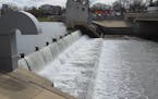
When the Red River crested at Fargo-Moorhead on Tuesday, it was 7 feet below the peak that experts had considered very possible only two weeks before.
That was a break for residents who have had to fight off five of the eight highest crests in history since 2001. But it also exposed blind spots in a system of flood prediction that river cities rely on in mounting their annual preparations.
It also generated criticism in Fargo that the city spent more time and money — about $3 million altogether — than necessary to protect against the high water. The mayor and others, however, defended the forecasters and the steps taken.
Conditions this spring were "climatologically unprecedented," said National Weather Service hydrologist Greg Gust, who is based in Grand Forks, N.D., along the Red. In most years, when the snow begins to melt and rivers break free of ice, the landscape along the Red remains frozen and impermeable, allowing meltwater to run quickly across fields and ultimately, into the Red.
But this year, because the cold extended into late April, the ground thawed quickly under high sun and soaked up the snowmelt, limiting runoff. Dry weather also helped. The delayed cold wasn't something hydrologists could put into their models, Gust said, because it wasn't part of the climate record; the 2013 crest was the latest since 1887.
"To try to anticipate something that's never occurred before has become an interesting and odd challenge," Gust said.
Steve Buan, hydrologist in the Twin Cities office of the weather service, said flood forecasters look at many factors in building a prediction: precipitation, air temperature, ground and surface water levels, the calendar and the weather forecast, among others. But this year's experience showed a need for more information on regional soil moisture content and the depth of frost in the ground. Those factors are more important in the northern U.S. than elsewhere, Gust noted, since spring flooding to the south rarely occurs while the soil is frozen. Although Minnesota has thousands of volunteer weather observers, few outside of universities and research organizations measure soil moisture and frost depths.
The barriers? "Cost and maintenance," Buan said.
The weather service has significantly refined its flood forecasting since 1997, when a higher-than-predicted crest — indeed, the Red's highest ever — devastated Grand Forks, N.D., and East Grand Forks, Minn. Then, Gust said, the weather service was unable to forecast water levels using above-normal precipitation, the signature feature of the winter of 1996-97. Now it develops probabilities using six decades of springtime weather history for key locations along the river.
The 2013 outlooks
This year, March snows left the equivalent of 5 to 7 inches of water atop the frozen landscape along the Red's upper reaches. At that point, the weather service said there was a 50 percent chance the river could exceed 38 feet at Fargo-Moorhead, and a 10 percent chance it could match the all-time high of 40.84 feet set in 2009. In mid-April, the service raised the 50 percent chance level to 40.3 feet, close to the record.
Fargo aims for protection to the 50 percent level, said Mark Bittner, the city's director of engineering.
"I was scared on this one," he said, adding that the city was soon reviving its volunteer sandbag efforts and aiming for flood protection to 43 feet — essentially the record level plus a desired 2 feet of "freeboard."
Unused resources
But last Tuesday's crest was more than a fathom below that.
It left Fargo with more than a million sandbags it won't be using, and Moorhead with some it will have to destroy because they're more than two years old, said city manager Michael Redlinger.
Fargo Mayor Dennis Walaker said the approximately $3 million the city will have spent on temporary flood protection measures — sandbagging, dike-building, cleanup and other tasks — is not money wasted, even though the safeguards weren't needed.
"To blame the National Weather Service is easy for a lot of people. We've had four floods in five years, so everybody's an expert," Walaker said. "To blame us for spending money to achieve protection levels higher than actually occurred is 20-20 hindsight."
"Flood forecasting is a science, but not an accurate science," he added "I sympathize with those guys. But as far as I'm concerned, we won the battle. That's what we should focus on."
Redlinger said Moorhead adapts to forecasts as they change. That's a luxury born of major permanent flood protections in recent years. The downside, if it can be described that way, is that both cities probably will fall far short of the damages needed to qualify for federal reimbursements.
Redlinger added that while this year's forecast missed the mark, flood forecasts are still "the best data we have — really the only data. It's still THE source for making decisions."
Bill McAuliffe • 612-673-7646

Fired Mpls. teacher accuses management of 'cancerous rot'

Jill Biden rallies women, teachers for the Biden-Harris ticket in Bloomington speeches
Neighbors, city officials at odds over Rochester lake dam

Souhan: This is KAT's chance to prove Flip Saunders was right