High winds, hail and rising waters smacked parts of Minnesota Tuesday, washing out roads and flooding homes, while the threat of more rain on Wednesday could turn some Fourth of July celebrations into a wet mess.
On Tuesday, officials in Renville, Lyon and Pipestone counties declared a state of emergency when torrential rains caused flash flooding, damaging roads and flooding homes. Meanwhile, farmers watched as rain pooled across already-sodden fields.
"Some of these areas have seen three to four times the average rainfall since June 1," said Twin Cities meteorologist Paul Douglas. "Once the water recedes, farmers will have to replant, and then it gets tight whether they'll make it to harvest."
Random storms may likely pop up on Wednesday in parts of Minnesota, including the Twin Cities, raising already-swollen creeks and rivers.
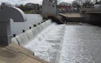
The Cottonwood River at New Ulm is expected to hit major flood stage on Friday. "There's a lot of water coming downstream," said Jake Beitlich, meteorologist with the National Weather Service in Chanhassen. The Minnesota River also will rise again with possible flooding near Henderson and Jordan. The Redwood River in southwestern Minnesota rose 17.4 feet on Tuesday, a record 3½ feet above flood stage, said Jeff Chapman, meteorologist with the National Weather Service in Sioux Falls.
Rain on Wednesday could drop another 2 inches or more in some of those areas along with a threat of severe weather that could bring strong winds and the possibility of a tornado, Chapman said.
Storms that barreled through western and central Minnesota brought 6 to 10 inches of rain to some areas and wind gusts as high as 70 mph, downing trees, according to Michelle Margraf, meteorologist with the National Weather Service in Chanhassen.
The Minnesota Department of Transportation issued a no-travel advisory for Murray County, and has closed the following highways: Hwy. 91 between 151st and 211th Streets; Hwy. 59 from 181st to 191st Streets, near Lake Shetek; Hwy. 19 at intersection of County road 5 to Marshall; and Hwy. 14 from Tracy to Walnut Grove.
Marty Seifert, the former Republican minority leader of the Minnesota House of Representatives, said he spent four hours pumping water out of the basement of his home in Marshall, Minn.
"We're just keeping up with the battle," he said early Tuesday afternoon. Numerous homes flooded, he said, and the local hardware store was overrun with people searching for wet vacs.
"They said it was pandemonium," he said. The city park that hosts Marshall's Fourth of July festival and fireworks was flooded Tuesday morning, and Seifert said it was unclear if events would be held.
Sgt. Eric Wallen of the Lyon County Sheriff's Office reported some vehicles were trapped by the rising waters.
In the Twin Cities, showers and a risk of severe weather on Wednesday may wash out some picnics and fireworks.
"Some communities might need a Plan B," said Douglas. "It's peak summer. It's peak heat. When it gets this hot and humid, the atmosphere is just agitated."
The timing and location of the storms will be hard to predict, but Douglas said he expects random storms to pop up in some areas early in the day and then again in the late afternoon and evening. In between, a combination of heat and humidity could make it feel like a 100 degrees, he said.
It will be enough to get people's attention but not as bad as last Friday when the mercury rose to 99 degrees with a heat index of 110.
Douglas predicts the Twin Cities could rack up more 90-degree days than normal through September. The Twin Cities averages about 13 of those days in the summer but Douglas said this summer could see 20 to 25 of those high-heat days. The Twin Cities already has hit 90 degrees nine times this year, he said.
"We'll see two or three more of those days next week," Douglas said. "Historically, the first and second week of July are the hottest of summer."
Meanwhile, June and early July are usually the wettest. That means Minnesota may start drying out in the next few weeks, Douglas said.
"That's more of a prayer than a prediction," he said.
Staff writer Matt McKinney and the Associated Press contributed to this report. Mary Lynn Smith • 612-673-4788

Minnesota State Patrol celebrates diverse new class of troopers

Fired Mpls. teacher accuses management of 'cancerous rot'

Jill Biden rallies women, teachers for the Biden-Harris ticket in Bloomington speeches
Neighbors, city officials at odds over Rochester lake dam