Well-timed, make that poorly timed, snowfall in the Twin Cities area Tuesday has brought the morning commute to a near-halt in some spots and extended drive times substantially on roads and freeways all around the metro area.
Overnight snow was light by Minnesota standards, but the 1 to 2 inches that fell was enough to turn highways slick and snarl traffic. The State Patrol responded to numerous spinouts and crashes between 5 and 7 a.m., with several vehicles landing in ditches.
Even as the usual time for morning rush hour's end drew near, congestion on snowy and slick roads had not loosened up even a bit.
One trouble spot continued to be northbound Interstate 35E from County Road 42 in the south metro to W. 7th Street in St. Paul. Travel wasn't much better on northbound 35W from Crystal Lake Road up to downtown Minneapolis.
Northbound Cedar Avenue in the south metro was a bit better but still taking 30 minutes from McAndrews Road to the Crosstown freeway. It was taking more than an hour to get from Woodbury to Minneapolis on I-94.
The National Weather Service (NWS) was reporting just 1 inch of snow in St. Louis Park, home to I-394, and Hwys. 100 and 169, among the busiest freeways in the metro. North St. Paul checked in with 1.5 inches. There was a smidge more than an inch measured in Prior Lake.
Unlike late last week, when extreme cold prompted late starts and even closings in areas on the edge of the metro and beyond, schools were proceeding with their day as scheduled Tuesday.
For the most part, the snowfall has come to an end in the Twin Cities. Temperatures are fairly moderate for this time of year, with the NWS calling for a high Tuesday in the upper 20s.
The chance of snow fades as the day and week proceed, the NWS added, and a warming trend is in the forecast. By the weekend, a high in the mid-30s is possible.
pwalsh@startribune.com • 612-673-4482
harlow@startribune.com • 612-673-7768
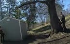
Body camera video shows Minnetonka man shooting at deputies several times before dying in firefight
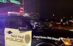
Charge: Driver going 77 mph ran red light, fatally hit man crossing St. Paul street and kept going
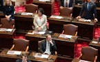
Minnesota Senate GOP files ethics complaint against Sen. Nicole Mitchell

High school archer focuses on target: another national championship