Only about one-third of the streams in Minnesota's farming regions will get the maximum amount of protection under new state buffer rules — a number that environmentalists say falls far short of what Gov. Mark Dayton's signature water protection law was intended to accomplish.
State regulators are drawing up a map of the streams, ditches, wetlands and lakes that will fall under the new and highly controversial buffer law — the nation's first — enacted last year in an effort to reduce pollution from farm runoff.
But they are relying on a decades-old list that excludes more than half the known small streams that create a web across Minnesota's landscape and carry sediment, phosphorus and other pollutants into the major rivers.
Officials from the Minnesota Department of Natural Resources (DNR) say the buffer law doesn't give them the authority or time to start from scratch in what would be a massive job of reviewing all the state's waters. The existing list, known as the Public Waters Inventory, was bitterly fought for years in the 1970s but is now widely accepted as the state's official catalog of waters subject to regulation.
Critics say the state is missing a one-time chance to do it right. Combined with Dayton's recent decision to exclude private ditches from state enforcement, Minnesota's first major piece of new environmental legislation in years will not come close to achieving its potential, they say.
"Buffers are hardly the silver bullet," said Scott Strand, head of the Minnesota Center for Environmental Advocacy. "But they are a part of what we can do on the landscape, and we should deploy them to the full extent that the law allows."
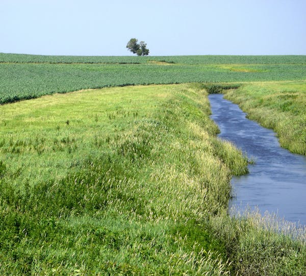
The buffer law, one of Dayton's hard-fought victories during the 2015 Legislature, was heralded by environmental groups and bitterly opposed by the state's leading farm groups. It was designed to strengthen existing law, which gives counties authority to require 16.5-foot buffers on drainage ditches and 50-foot buffers on streams, lakes and wetlands.
Those rules were confusing and rarely enforced, and many of the buffers are missing. Dayton's $28 million buffer law clarified the rules and added financial penalties. But the political fight never really ended. Farm groups and Republicans vehemently challenged the DNR's assertion that private ditches — those constructed and paid for by individual landowners — were subject to the same penalties that apply to publicly maintained drainage ditches.
Adam Birr, executive director of the Minnesota Corn Growers Association, said resistance was driven in part by the view of some farmers that their ditches are protected by private property rights. But mostly, he said, farmers were confused because there is no official list or map of private ditches, and they weren't sure how the law would apply to their land.
"It was seen as a constraint to implementing the law," he said. "Our folks were concerned about meeting the timelines."
Two weeks ago Dayton agreed to exempt private ditches, saying that he had "caved" to pressure from agricultural groups and Republican legislators.
Whose list is right?
At the same time, environmental groups have been fighting their own battle with the DNR about another term in the law. The critical question: What, exactly, is a public water?
In contrast to public ditches, all public lakes, streams and wetlands would require an average width of 50-foot buffers — considered far more effective than the 16.5-foot version — or other approved protective measures. DNR officials say they don't intend to use state's legal definition of a public water — any body that drains 2 square miles of land. Instead, they'll use the long-established public waters inventory.
That, too, was the product of a bitter and long political fight in the 1970s, fought county by county and through legal appeals, to determine which bodies of water would fall under state permit requirements.
"It was very controversial, a lot of angry meetings," said Dave Leuthe, a DNR program consultant who worked on the inventory then, and last year was called out of retirement to help with new buffer mapping project. "You didn't always feel safe or secure."
But when it was finished, the final list omitted a lot of the smaller streams — some of which could be draining 2 square miles and are the most intimately connected to agricultural lands.
"If this is going to exclude a bunch of smaller streams, it will substantially reduce the benefit to them all," said Craig Cox, a vice president at the Environmental Working Group, a national nonprofit that has mapped Minnesota's waters and buffers.
One state analysis, covering 67 counties, found the list includes 21,642 miles of streams — and omits 28,760.
The same is true for streams that were turned into ditches — 4,731 miles are public waters and 15,381 are not.
'Missed opportunity'
Sarah Strommen, assistant DNR commissioner, said the agency's map is still a work in progress. Some of those stream and ditch miles might yet be included, and county governments are responsible for managing and enforcing buffers on the rest. But, she said, the DNR is not going to go through the whole ordeal of debating public waters again.
"We don't see any intent in [the new law] that we go through another similar extensive process to update that inventory," she said.
Environmental groups disagree, saying the DNR has chosen expediency over the best water protection.
"To knowingly give out an incomplete map is a huge missed opportunity," said Trevor Russell, program director at Friends of the Mississippi River.
Regardless, many of the people charged with implementing the law across Minnesota's farm lands say it has changed the conversation.
"I think people understand that it's the law now," said Michele Stindtman, program manager for the soil and water district in Faribault County, which is 99 percent agricultural land. "They are calling to find out, 'Am I 16 ½ or am I 50?' "
The DNR expects to complete its preliminary map in the next month and will make it available on its website (www.dnr.state.mn.us/buffers/index.html) for review by local governments and other groups. The final map must be done by July, and buffers must in place in 2017 and 2018.
Josephine Marcotty • 612-673-7394

Minneapolis considers bid to host Sundance Film Festival

Teen suspect in Nudieland mass shooting arrested on murder, assault charges
'Human error' behind Robbinsdale shelter-in-place alert that was mistakenly sent countywide

Going to Wolves or Twins tonight? How to get there (and maybe avoid traffic).