The wettest June in Minnesota history is over, leaving flooding, road washouts, wet campsites and drowned and damaged crops in its wake. Or, in its no-wake zone.
From the Canadian border to the Iowa line, many communities saw more rain in June than ever before. The Twin Cities saw the second-most rain and the most since 1874.
State climatologist Greg Spoden didn't hesitate when asked what impressed him about the rains.
"The geographic extent — that this huge state had such heavy rain," he said.
How heavy? Let us count the ways.
The average rainfall collected by hundreds of volunteers in the hundreds of rain buckets around the state is likely to be above 8 inches, once the accounting is done, Spoden said. That would easily knock off the record of 7.32 set in 1897 and tied in 1914.
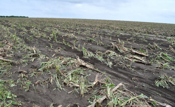
But that's the broad average. Redwood Falls saw 15.24 inches. Luverne, also in southwestern Minnesota, had 13.84. Kabetogama, nearly 500 miles to the north, had 11.58 — all local records. In the Twin Cities (11.36), and International Falls (10.19), it was No. 2 on the list.
Farmers in southwestern Minnesota may not be able to salvage much from fields where crops were first damaged by hail, then by high water. Many roads and bridges across Rock County are still closed, said Eric Hartman, director of the land management office in Rock County, one of four southwestern Minnesota counties where officials from the Federal Emergency Management Agency Land Management Office will be measuring damage to public facilities beginning Tuesday.
In St. Paul, where the Mississippi River reached its seventh-highest crest on record and highest June crest ever on Thursday, officials noted Monday that an unusually high amount of silt in the floodwaters will slow the cleanup of roads, trails and parks. The river had declined 2.5 feet by Monday afternoon, but low-lying riverfront areas and roads were still inundated.
Tough month for campfires
The rains made for a month of improvisation at summer day camp at Dodge Nature Center in West St. Paul. Campers had to clear trails on opening day June 16. Since then, they've contended with flooding, power failures and wet clothing, while many of their parents were contending with flooded basements at home, said naturalist Pete Cleary.
But they learned how to build fires with wet materials, how to form a chain to cross a small creek, usually taking water into their boots.
"They get to the other side and they say, 'Can we do that again?' " Cleary said.
June brought the Twin Cities its sixth-wettest calendar day in 143 years of records (4.13 inches, June 19), helping push Lake Minnetonka to its all-time high level. The lake and Minnehaha Creek, which it flows into, are likely to remain over or filled to their banks through July, said Minnehaha Creek Watershed District spokeswoman Telly Mamayek.
Widespread flooding was actually set up long before June, when a heavy winter snow melted late and saturated soils across the state, said National Weather Service hydrologist Craig Schmidt. Also, because the cool, wet April and May delayed spring planting, there weren't enough crops in the field to suck up some of the rain before it ran into rivers, Schmidt added. In the Twin Cities, precipitation for April, May and June measured 22.18 inches, more than twice the normal.
But it wasn't a total disaster. Tornadoes were few (the total isn't official yet), and the Twins didn't have a single rainout.
After strong chances of rain Tuesday, the Twin Cities may see dry conditions into next Monday. After that, the national Climate Prediction Center sees chances for above-normal precipitation for western Minnesota though September, but no clear trend for the rest of the state. Temperatures may trend cooler than normal.
Cleary said he hopes the change in the calendar will have the same effect that it did the last three summers, when wet springs were reversed by dry middle and late summers.
"I'm waiting for that shoe to drop," he said.
Bill McAuliffe • 612-673-7646

FAFSA completions in Minnesota drop amid flawed efforts to update form

Wisconsin Republicans ignore governor's call to spend $125M to combat 'forever chemicals'
Man killed in Minnetonka by law enforcement started gun battle with deputies, BCA says