John Jefferson, a retired FBI agent, resigned in February after a lengthy HR investigation into numerous allegations, including his decision to reenact police restraint holds on civilian staff without warning or consent.
Eder Campuzano, Star Tribune
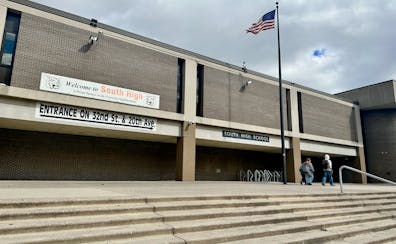
A former South High School math teacher says she was fired for speaking up against administrators' inability — or unwillingness — to address or even document extremely disruptive student behavior.
Renowned Russia expert Fiona Hill reflects on the Kremlin's propaganda program, what President Vladimir Putin is thinking and how U.S. divisions impact international issues.
Your trusted source for Minnesota news today. Read articles, view photos, or watch videos about news in Minneapolis, St. Paul, Twin Cities Metro areas, St. Cloud, Rochester, and beyond. The Star Tribune is committed to provide more of what matters to Minnesotans. All day. Every day.


![Capella Tower at 225 South Sixth St. Tuesday September 6, 2011. ] GLEN STUBBE * gstubbe@startribune.com Minneapolis skyline from the 51st floor of IDS](https://arc.stimg.co/startribunemedia/7C263DJZQTPRDEXI74SMH2M3HI.jpg?h=91&w=145&fit=crop&bg=999&crop=faces)